Mixed period with no standout days
Western Australian Forecast by Craig Brokensha (issued Friday September 27th)
Best Days: Perth/Mandurah for the keen tomorrow morning, Tuesday all locations
Features of the Forecast (tl;dr)
- Mix of moderate sized SW swells tomorrow with fresh S/SW tending SW winds in the South West, variable offshore to the north in the AM
- Easing swell Sun with W/SW winds in the South West, NE across Perth/Mandurah in the AM
- Moderate sized mid-period SW swell building Mon PM, peaking Tue AM, easing
- Variable winds in the South West Mon AM ahead of sea breezes, E'ly to the north
- E/NE tending N winds Tue
- Strengthening N/NW winds Wed
- Large W'ly swell Thu with winds unsure
Recap
Yesterday’s winds played out more favourably than expected with clean conditions most of the morning across the South West with a fun 3-5ft of swell, decent in Mandurah and Perth with small waves for the keen.
Today a trough is moving through bringing an onshore change and poor conditions to all locations. A window of early light winds across Perth/Mandurah didn’t eventuate.
This weekend and next week (Sep 28 - Oct 4)
A spike of SW groundswell due today from a tight low that formed south-west of us mid-week is due to ease into tomorrow morning, but a new pulse of mid-period SW swell is due to arrive through the afternoon.
The source was a distant storm south-east of South Africa, with the South West due to hold 4-6ft all day with 1-1.5ft sets to the north.

Winds will remains onshore tomorrow in the South West, fresh from the S/SW tending SW with a window of local offshore winds across Perth/Mandurah in the morning.
Sunday looks smaller with the mid-period SW swell on the wane with W/SW winds persisting in the South West, NE in Perth/Mandurah ahead of W/NW sea breezes.
Moving into next week, and a groundswell due Monday/Tuesday has been downgraded in size and strength with a mid-period SW swell now on the cards.
The swell generating frontal progression looks much weaker with a fetch of strong to sub-gale-force W/SW winds due to move through our swell window over the coming days.
The swell should build Monday and reach 5-6ft or so into the afternoon/evening across Margs, peaking Tuesday to 6ft with Perth/Mandurah seeing 1-2ft waves.
Conditions will be more favourable though thanks to the weaker progression, with variable breezes across the South West Monday morning ahead of the swell, E’ly to the north ahead of sea breezes. Tuesday should then see an E/NE offshore, tending more N-N/NW into the afternoon but without any major strength.
Wednesday will then be poor as winds strengthen from the N/NW thanks to a high projecting, significant low forming west of us.

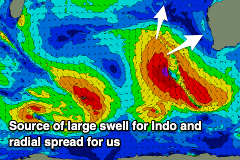
This low will be quite meridionally aligned (south-north), compared to zonal (west-east) and as a result most of the swell potential from the severe-gale to storm-force fetch will be aimed towards Indonesia.
We should see some side-band W/SW groundswell energy spreading out radially from the low though, arriving later Wednesday but peaking Thursday to the 6-8ft range in the South West, 3ft Mandurah and Perth owing to the west nature and swell source.
The models still diverge regarding the strength and intensity of this low still along with the local winds with EC having more variable breezes as the low moves north and across us, more onshore going by GFS. Check back here on Monday for a clearer idea on the wind outlook.
Longer term there’s plenty more swell potential for the start of October. Have a great weekend!


Comments
Box cam 7am Wednesday, whale putting on an incredible display for the small group out there!
Thanks again Craig ... only 1-1.5ft sets to the north? Really? I thought itd be much bigger first thing in Perth & Mandurah than that?