Make the most of today
Western Australian Forecast by Craig Brokensha (issued Wednesday September 25th)
Best Days: Today, Perth and Mandurah Friday morning, Monday morning, Tuesday morning
Features of the Forecast (tl;dr)
- Fading swell tomorrow with early E/NE tending fresh N then NW and W/SW winds
- Moderate + sized SW groundswell Fri with strong SW winds in the South West, S/SE to the north in the AM
- Easing swell Sat AM, with a new mid-period pulse for the PM, easing Sun
- S/SW winds in the South West Sat, S/SE-SE to the north in the AM
- W/SW winds in the South West Sun AM, E/NE to the north in the AM
- Mod-large sized mid-period SW swell building Mon, peaking overnight, easing Tue
- Variable winds Mon AM ahead of sea breezes, E/NE tending NW Tue
- Larger surf later next week with strong W winds
Recap
Conditions were more miss than hit yesterday morning with a mix of easing swell energy and new, reinforcing mid-period swell, best across Perth and Mandurah during the morning.
Today is much better with clean, windy conditions across the South West as sets hold 6ft, smaller and to 2ft in Mandurah with inconsistent 1-2ft waves across Perth. The swell will ease through the day as winds go variable.

Great conditions today
This week and weekend (Sep 26 - Oct 4)
The current swell energy which has already started to wane will continue to ease tomorrow and with less favourable winds, E/NE at dawn but quickly shifting N’ly and freshening with a late afternoon/evening W/SW change due.

The earlier stages of the trough responsible for this change is generating a tight fetch of gale to severe-gale SW winds and will produce a moderate sized spike of swell for Friday.
The South West will be onshore with gusty SW winds, while Perth and Mandurah should see a period of S/SE winds but small surf to 2ft.
Saturday morning looks temporarily smaller as winds remain S/SW in the South West, better and S/SE-SE to the north.
Into the afternoon some new moderate sized mid-period SW swell energy is due, generated by a distant storm to the south-east of South Africa earlier this week.
No major size is due across, with Perth and Mandurah unlikely to top 1-1.5ft, easing through Sunday as winds persist from the W/SW across the South West with E/NE breezes to the north.
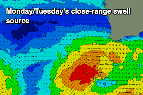
Into Monday afternoon/Tuesday, some larger mid-period SW swell is due to fill in, generated by a healthy but not overly strong stream of frontal system glancing the South West through the weekend/Monday.

A peak to 6-8ft is likely in the South West later Monday and Tuesday morning, 2ft+ in Mandurah and 2ft across Perth and with light morning offshores ahead of sea breezes in the metro regions, more variable and possibly S/SE to the south in the morning Monday.
Tuesday looks the pick with an E/NE offshore ahead of sea breezes.
Just behind this close-range system looks to be a stronger polar low firing up, with a large W/SW groundswell likely from it later next week but with strong onshore winds. More on this Friday.

