Fun Wednesday, then average
Western Australian Forecast by Craig Brokensha (issued Monday September 23rd)
Best Days: Protected spots tomorrow, Wednesday, Perth and Manduran Saturday/Sunday mornings, Tuesday morning Perth/Mandurah, Wednesday morning
Features of the Forecast (tl;dr)
- Mix of easing groundswell tomorrow and new mid-period S/SW swell for the PM, easing Wed
- Strong S/SE winds tomorrow, weaker to the north
- Fresh E/SE tending E/NE then variable winds Wed
- Smaller, easing surf Thu with strong NE tending N/NE and then N/NW winds
- Strong SW winds Fri
- Moderate + sized mix of swells for the weekend with gusty SW winds to the South West, variable to the north Sat, NW Sun with N/NE winds to the north
Recap
Saturday was a bit so/so across the coast with easing swell under less than ideal winds across the South West, best in Perth/Mandurah.
Yesterday was cleaner but smaller with Margs performing best, while today we’ve seen a mix of new groundswells building across the state with great conditions inside protected spots this morning, now bumpy and onshore.
This week and weekend (Sep 24 - 29)
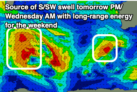
Strong frontal activity to our south and south-west have generated today’s mix of S/SW and SW groundswell with a peak due this afternoon to 6-8ft in the South West, 2ft+ across Mandurah with 1-2ft sets in Perth.
This swell is due to ease back through tomorrow, with a moderate sized mid-period S/SW swell from a final trailing front currently to our south-west due to steady the dropping trend into the afternoon, easing Wednesday.
Surf to 6ft is due in the South West, 1-2ft Mandurah with tiny waves across Perth most of tomorrow, easing from a similar size Wednesday and with strong, cross-shore S/SE winds tomorrow morning in the South West, weaker but still S/SE to the north, E/SE across all spots on Wednesday, tending E/NE and then weak sea breezy.

This looks to be the pick of the week with Thursday morning coming in smaller and with less favourable, strengthening NE-N/NE tending N/NW winds.
These strengthening winds will be ahead of an approaching trough which will move through Friday bringing a strong SW change.
Unfortunately this will be the first in a stream of frontal activity bringing more onshore winds but only moderate levels of swell into the weekend. The South West will be onshore but windows of lighter winds are due around Perth and Mandurah with 1-2ft sets.
We’ll likely see the last of these fronts strengthening on approach Sunday, projecting a fetch of W/SW-SW gales up and into us. A large, close-range swell is due from this system building Sunday and peaking Monday with surf to 10ft+ due across the South West, 3ft+ Mandurah and 2-3ft Perth but with strong SW winds.
Tuesday looks better across Perth/Mandurah but still lingering onshore in the South West as the swell generating front clears along with easing levels of swell.
Longer term, large groundswell energy is likely later in the week with hopefully better winds. More on this Wednesday.

