Fun swell pulses this period but with tricky winds
Western Australian Forecast by Craig Brokensha (issued Friday September 20th)
Best Days: Protected spots tomorrow morning, Margs Sunday morning, Wednesday morning
Features of the Forecast (tl;dr)
- Easing swell tomorrow, with a moderate + sized reinforcing SW swell for the PM, easing Sun
- S/SE-SE tending SW winds Sat, SE in the AM to the north
- Light E winds ahead of strong sea breezes Sun
- Mod-large mix of S/SW groundswell and SW groundswell for Mon, peaking into the PM with early S/SE tending strong S/SW winds
- Easing surf Tue with strong S/SE winds
- Moderate + sized mid-period SW swell Wed with E tending SW winds
- Large W/SW groundswell for next Fri/Sat
Recap
Conditions were clean and fun across the South West yesterday morning with tiny waves to the north. A new pulse of S/SW groundswell started to show into the afternoon with it peaking this morning across all locations.
Winds weren’t as favourable though with bumpy 8ft surf on the exposed reefs in the South West, cleaner and to 2-3ft across Mandurah and 1-2ft in Perth.
This weekend and week (Sep 21 - 27)
Following the strong polar fetch linked to today’s S/SW groundswell, backup fronts have been generating strong to gale-force W-W/NW winds.
This will result in some fun sized, reinforcing mid-period SW swell through tomorrow afternoon, easing Sunday.

The South West should hold the 5-6ft range most of the day tomorrow before easing Sunday from 4-6ft, 2ft in Mandurah and 1-1.5ft across Perth tomorrow, smaller Sunday.
Winds will remain less than ideal and S/SE-SE across the South West, SE to the north ahead of sea breezes.
Sunday should offer better conditions with a light E/NE offshore across the South West, E/SE-SE to the north ahead of sea breezes.
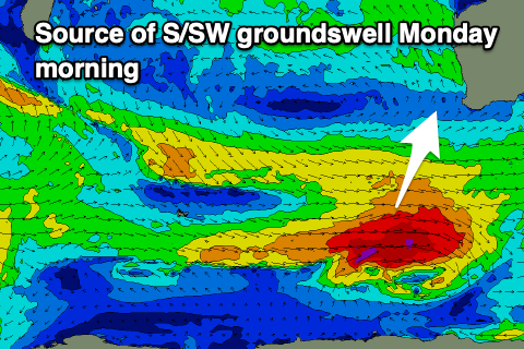
Into Monday, a mix of new S/SW groundswells are due, generated by late forming storms in our swell window today through tomorrow.
A polar low should generate gale to severe-gale W/NW winds today, producing a pulse for Monday morning, with a secondary closer storm generating similar strength winds south-west of us tomorrow. This should produce a slightly better pulse of groundswell for the afternoon.
Size wise the South West will see the most energy with the morning coming in at 5-6ft ahead of a stronger pulse to 6-8ft into the afternoon, easing Tuesday. Mandurah looks unlikely to top 2ft with tiny waves in Perth.
Winds will be unfavourable in any case and S/SE tending strong S/SW on Monday, strong S/SE on Tuesday.

Wednesday looks cleaner with a new moderate + sized mid-period SW swell to 6ft or so in the South West, 1-2ft to the north.
Longer term, a strong persistent low firing up south-east of South Africa will move through the Southern Ocean over the coming days and early next week, generating a sustained fetch of gale to severe-gale force W/SW winds.
A large W/SW groundswell is due from this source next Friday/Saturday but with what looks to be unfavourable local winds. More on this Monday. Have a great weekend!

