Trickier wind outlook with a couple of swells to work with
Western Australian Forecast by Craig Brokensha (issued Wednesday September 18th)
Best Days: Tomorrow morning in the South West for the keen, Friday morning, Sunday morning in the South West, Monday morning in the South West
Features of the Forecast (tl;dr)
- Small easing mid-period W/SW swell tomorrow with moderate E/SE winds (SE to the north) ahead of sea breezes
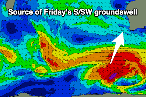
- Large S/SW groundswell arriving late tomorrow, peaking Fri AM with S/SE-SE winds, stronger S/SW into the PM
- Easing swell Sat, with a moderate + sized reinforcing SW swell for the PM, easing Sun
- S tending SW winds Sat, SE in the AM to the north
- Light E winds ahead of sea breezes Sun
- Moderate + sized S/SW groundswell Mon with SE tending S/SW winds
Recap
Small to tiny waves across Perth and Mandurah yesterday morning, with clean fun 3-4ft surf across the South West magnets ahead of sea breezes.
Early this morning the swell was at a low point, but since we’ve seen our small mid-period W/SW swell filling in with 1.5ft waves across the metro locations, small to the south. Winds aren’t ideal though and it’s for the desperate.
This week and next (Sep 19 - 27)
Today’s small pulse of mid-period W/SW swell is due to peak through the afternoon and ease tomorrow as winds shift offshore.
We could see lingering 1.5ft sets across the metro regions, 3-4ft down in the South West along with a moderate E/SE breeze, SE to the north before giving into sea breezes.

Late in the day but more so Friday, our good pulse of S/SW groundswell is due to arrive, with a strong polar low that’s currently south-south-west of us, generating fetches of gale to severe-gale W/SW winds.
The swell should come in at 6-8ft+ across the South West with 2ft+ sets in Mandurah, 1-2ft across Perth before easing through the day.
Winds on Friday aren’t ideal but OK and should be SE-S/SE across the South West, SE to the north before freshening from the S/SW into the afternoon, smaller Saturday and with less favourable S’ly winds developing in the South West, cleaner to the north.
A moderate + sized reinforcing mid-period S/SW swell is due Saturday afternoon, generated by a weaker trailing front moving through our swell window this evening and tomorrow.
It’ll hopefully maintain 4-6ft sets across the South West into the afternoon, easing Sunday from 4-5ft with 1-1.5ft waves across Perth/Mandurah.

A better E’ly offshore is due on Sunday with this easing swell before sea breezes kick in.
Another pulse of S/SW groundswell is then due into Monday, produced by a stronger trailing frontal system developing on the tail of the activity ahead of it, with a fetch of severe-gale W/NW winds due to kick up 5-6ft sets in the South West, 1-2ft to the north at best and with SE morning winds ahead of sea breezes.
Following this we’ve got a bit of down time between swells ahead of some larger stuff possibly into the end of the month, start of October (but with onshore winds). More on this Friday.

