Average week apart from one morning
Western Australian Forecast by Craig Brokensha (issued Monday September 16th)
Best Days: Friday morning
Features of the Forecast (tl;dr)
- Small to tiny tomorrow with E/NE-NE tending NW winds
- Small, mid-period W/SW swell for Wed, easing Thu
- Strengthening S/SE winds Wed tending S/SW to the north during the day, E/SE Thu AM ahead of sea breezes
- Moderate+ sized S/SW groundswell building later Thu, peaking Fri AM with E/SE tending S/SW winds
- Easing swell Sat with S tending SW winds
- Smaller Sun AM with variable tending W/SW winds
- Building S/SW swell Sun PM, peaking Mon with E winds to the north, W to the south
Recap
Great surf on the weekend as Friday’s swell slowly eased, backing off from 6ft+ in the South West, 2ft+ across Mandurah and 2ft in Perth.
Yesterday was smaller but fun across the South West magnets, small and slow to the north with a little less size again today along with winds tending more northerly.
This week and weekend (Sep 17 - 22)
As touched on in last week’s update, the coming period isn’t too crash hot at all with a lack of strong frontal activity in the Southern Ocean to our west and south-west.
We’ll see the current swell continuing to ease tomorrow, while into Wednesday an inconsistent, small mid-period W/SW swell is due to arrive across the state. With no other swell sources in the water, it’s worth noting but the metro locations are unlikely to top 1-1.5ft while Margs should come in at 3-5ft.
Winds will take a shift to the S/SE and strengthen on Wednesday in the wake of a trough, with Thursday seeing a return to E/SE offshore winds as the swell fades.
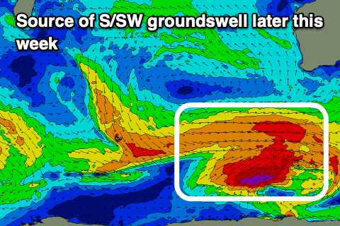
We then look to the south later week, where a strengthening Southern Ocean progression is set to take place from tomorrow through the end of the week.

An initial polar low is due to generate a fetch of W-W/SW gales late in our swell window, generating a moderate + sized groundswell for Friday morning (arriving later Thursday).
It’s nothing special but worth capitalising on with sets to 6ft+ due in the South West, 1-2ft in Mandurah and 1-1.5ft across Perth along with a morning E/SE offshore, tending S/SW and strengthening into the afternoon with a trough.
Less favourable S’ly winds are then due on Saturday as the swell eases, smaller Sunday morning with a period of variable winds before freshening from the W/SW.
Further slightly smaller pulses of S/SW swell are due into Sunday afternoon and early next week owing to secondary fronts firing up in our southern swell window, but local winds won’t be as favourable with the swell generating fronts due to clip the state. We may also see one of the fronts spawning a mid-latitude low.
This will spoil conditions most of next week but we’ll have a closer look at this on Wednesday.

