Onshore winds kick back in from tomorrow
Western Australian Forecast by Craig Brokensha (issued Monday September 2nd)
Best Days: Protected spots this afternoon in the South West, Perth and Mandurah this afternoon, early tomorrow Perth and Mandurah, Friday morning for the keen Perth and Mandurah, Sunday and Monday mornings all locations
Features of the Forecast (tl;dr)
- Easing swell tomorrow with E/NE-NE winds early across Perth/Mandurah (shifting W mid-AM), W'ly in the South West from dawn
- Large mid-period W/SW swell mixed with a new SW groundswell Wed under strong W-W/SW winds
- Large W/SW swell Thu with strong W/SW-SW winds
- Easing surf Fri with N/NE tending NW winds across Perth/Mandurah, fresh to strong W/SW tending W/NW Margs
- Smaller Sat with strong W/SW winds
- Large SW swell with variable offshore winds ahead of sea breezes, easing Mon with E tending W winds
Recap
Terrible conditions all weekend with more frontal activity and large, onshore surf across the South West.
Today we’ve finally seen winds swing offshore with a large, building SW groundswell that’s now hitting 10ft on the sets across Margaret River with 3ft sets across Mandurah and slower 2ft to occasionally 3ft sets in Perth. Winds have gone a bit more north and will strengthen further in the South West before backing off later.

New swell this AM (spot the surfer)
This week and weekend (Sep 3 - 8)
Today’s building SW groundswell is due to peak this afternoon/evening, easing back slowly through tomorrow with a window of early E/NE-NE winds due across Perth and Mandurah, with W’ly winds for the get go in the South West.
Easing 2-3ft waves are due across Perth and Mandurah, with onshore winds kicking in from mid-late morning.
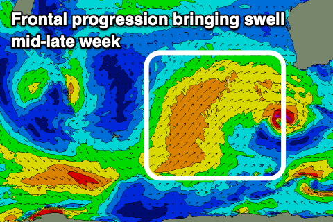
These strengthening winds are thanks to a broad, strengthening frontal progression pushing up and across us over the coming days, bringing with it a large increase in mid-period W/SW swell later Wednesday, peaking through Thursday but still large Friday morning.
There’s also due to be some stronger SW groundswell Wednesday morning from a fetch of W/NW severe-gales currently south-west of us, but with strong W-W/SW winds, there’ll be nowhere to hide.

Winds will shift a little W/SW-SW on Thursday but remain strong with the swell coming in at 10-12ft across the South West, 4ft+ Mandurah and 3ft+ Perth.
Friday looks cleaner across Perth and Mandurah with a N/NE breeze and easing surf from 3ft in Perth, 3-4ft Mandurah and 10ft across the South West.
Come the weekend, easing surf is due on Saturday with what looks to be onshore W/SW winds across all locations, with Sunday seeing a new, large pulse of mid-period SW swell as winds ease and tend locally offshore across most spots.
The mid-period swell will be generated by a healthy polar front tracking up towards us later this week, with wind speeds maxing at gale-force.
8ft+ sets should still be in the South West with 2-3ft waves across Mandurah, 2ft in Perth, smaller Monday with offshore winds again.
Longer term it looks like onshore winds will kick back in mid-late next week, but more on this Wednesday.


Comments
Like to say a 2nd surf report would of been nice this morning.
Incredible ocean today. Things u see you'll remember forever.