Poor weekend, good early next week
Western Australian Forecast by Craig Brokensha (issued Friday August 30th)
Best Days: Monday, Friday
Features of the Forecast (tl;dr)
- Large S/SW groundswell easing tomorrow with strong W/SW winds, easing Sun with strong but easing SW winds
- Inconsistent, long-period SW groundswell building Mon, peaking through the day with E/NE tending N/NW winds in the South West, variable to the north
- Easing swell Tue with strong W/NW winds (possibly variable early in Perth/Mandurah)
- Large close-range SW swell for Wed PM and Thu AM with strong WNW-W winds Wed, SW and easing Thu
- Variable winds Fri with a large, mid-period SW swell
Recap
Strong onshore winds have made a mess of all regions both yesterday and today with more on the way for the weekend.
This weekend and next week (Aug 31 - Sep 6)
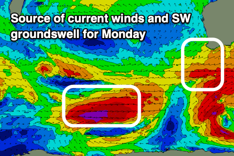
The current onshore winds are thanks to a strong polar frontal progression projecting up and clipping us, with a large S/SW groundswell due this afternoon and tomorrow morning but with persistent strong W/SW winds tomorrow, SW and easing into Sunday.
We’re still looking at our great, offshore wind on Monday morning with E/NE breezes due across most locations, shifting N/NW into the afternoon across the South West and variable to the north.

Swell wise, we’ve got the long-period SW groundswell due to fill in during the day Monday, generated by the strong but tight and short-lived polar low that formed west of the Heard Island region yesterday.
Storm-force winds should see 10ft sets across the South West (likely odd bigger one at the peak), more so from later morning with building sets to 2-3ft across Mandurah and 2ft in Perth during the afternoon.
Make the most of this window as winds will quickly strengthen from the W/NW on Tuesday, with a possible early variable breeze in Perth but with smaller, easing surf.
This change will be linked to the next swell generating front approaching out of the south-west, with it now looking a little stronger than forecast earlier in the week.
We should see a good fetch of strengthening gales approaching us, producing a mix of mid-period and groundswell for Wednesday afternoon/Thursday morning.
Surf to 12ft is due across Margs with 4ft sets in Mandurah, 3-4ft across Perth but with strong W/NW-W winds on Wednesday, shifting SW Thursday and easing.
Friday looks like another clean window as winds likely ease between fronts and tend variable offshore, but with lots of lump in the South West. Large levels of mid-period SW swell should still be in the water but we’ll review this and a possible longer window of lighter winds and cleaner conditions Monday. Have a great weekend!

