One day to work with this period
Western Australian Forecast by Craig Brokensha (issued Wednesday August 28th)
Best Days: Monday
Features of the Forecast (tl;dr)
- Strong W/SW winds tomorrow with large, building surf again, easing Fri with strong W/SW winds
- Large S/SW groundswell building late Fri, peaking Sat
- Strong W/SW-SW winds Sat, mod-fresh but easing W/SW Sun
- Large, long-period SW groundswell building Mon, peaking in the PM, easing Tue
- E/NE tending N/NW winds in the South West Mon, E tending S/SW to the north
- Strong W/NW winds Tue
- Onshore winds and large, mid-period surf Wed
Recap
Yesterday saw large, poor stormy conditions across all locations, while this morning we’ve got easing surf with cleaner conditions around Perth with 2-3ft sets, 3-4ft across Mandurah and best in protected locations with onshore winds easing but continuing across the South West.
This week and next (Aug 29 - Sep 6)
This morning’s window of cleaner conditions will be short-lived, with the next approaching swell generating front due to bring strengthening N/NW winds this afternoon, shifting W/SW tomorrow as the front clears east.
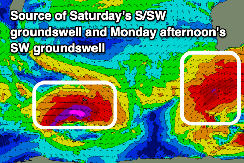
The front will generate a great fetch of gale to severe-gale SW winds to our south-west over the coming days, producing a large mid-period SW swell tomorrow followed by a larger S/SW groundswell Friday afternoon and Saturday morning.

This groundswell should reach 10-12ft across the South West with 3-4ft waves in Mandurah, 2-3ft across Perth. Winds on Friday are expected to remain strong from the W/SW-SW with Saturday unfortunately seeing persistent, strong W/SW breezes.
Sunday will see the onshore breezes starting to ease but remaining moderate to fresh through the morning with an outside chance of more variable winds early around Perth/Mandurah. We’ll review this Friday.
Winds will finally swing offshore across Perth and Mandurah Monday morning out of the E, with E/NE-NE winds across the South West along with an inconsistent, large pulse of SW groundswell.
This swell is due to fill in through the day, peaking into the afternoon as winds go sea breezy.
The source of this swell will be a strong but short-lived polar low forming west of the Heard Island region this evening and tomorrow, generating a fetch of severe-gale to storm-force W/NW winds before weakening as a frontal system spawns off it and races ahead towards Victoria.
This will limit the swell potential a little but but the South West should build to 10ft on the sets, 2-3ft across Mandurah and 2ft in Perth, easing Tuesday along with a return to strengthening W/NW winds.
The return to onshore winds will be thanks to a not overly strong, mid-latitude frontal system slowly moving in from the west, bringing with it large, onshore surf into the middle of next week.

