Make the most of today and early tomorrow
Western Australian Forecast by Craig Brokensha (issued Wednesday August 21st)
Best Days: Today, early tomorrow, later next week
Features of the Forecast (tl;dr)
- Easing swell tomorrow with strengthening E/NE tending stronger NE-N/NE winds, then NW into the PM
- Strong W/NW-NW winds Fri
- Strong to near-gale-force W/NW-W winds Sat with an oversized, building stormy swell
- Peak in stormy swell early Sun, easing with fresh to strong W winds
- Large W/SW groundswell Mon with strong N/NW winds
- Easing surf Tue with strong W/NW-NW winds
Recap
Poor surf yesterday and a further drop in swell, while today we’ve got variable offshore winds and improving conditions across all locations along with a large, inconsistent W/SW groundswell on the build.
The South West was 8ft on the sets with 2-3ft waves to the north with the swell due to reach 10ft around Margs this afternoon, 3-4ft across Mandurah and a more convincing 2-3ft in Perth. This will be with weak afternoon sea breezes.

A window of cleaner conditions this morning
This week and next (Aug 22 - 30)
This afternoon’s peak in inconsistent W/SW groundswell is expected to ease through tomorrow as winds swing E/NE and strengthen across all locations, shifting NE and then NW into the afternoon.
Go early for the best surf with easing sets from 8ft across the South West, 2-3ft in Perth and Mandurah.
Friday then looks like a lay day across all locations with smaller surf and strengthening W/NW-NW winds, becoming even stronger Saturday as a series of cold fronts push in from the west.

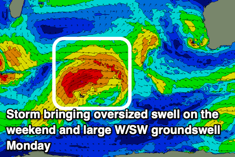
Initial frontal activity on Friday looks generally weak while the weekend’s system has originated south of South Africa and will track towards us while generating fetches of gale to severe-gale W/SW winds. On approach it’s due to weaken but then strengthen again once over us, kicking up a large stormy localised swell for Saturday afternoon and Sunday, with the groundswell to follow on Monday.
The South West looks to reach a stormy 12-15ft on Sunday with 5-6ft waves in Mandurah and 3-5ft sets across Perth but with strong to gale-force W’ly winds later Saturday, easing Sunday but remaining strong from the W.
Monday will see winds tip back N/NW as the next swell generating system approaches along with the groundswell that looks to be in the 12ft+ range across the South West, 4ft Mandurah and 3ft Perth.
As the swell eases strong W/NW-NW winds will continue to create poor conditions on Tuesday across all locations with what looks to be no let up until Friday.
Swell wise, a stalling Southern Ocean Gyre to our south-west looks to project back to back frontal systems towards us through next week, producing further large pulses of SW groundswell mid-late next week and beyond.

