Limited windows of favourable winds with the coming swell
Western Australian Forecast by Craig Brokensha (issued Monday August 19th)
Best Days: Wednesday morning most locations, Thursday
Features of the Forecast (tl;dr)
- Fresh to strong W-W/NW winds tomorrow with a building mid-period swell
- Large, inconsistent W/SW groundswell for Wed with E/NE winds in Perth/Mandurah, S/SE across Margs, onshore into the PM
- Easing swell Thu with mod-fresh E/NE tending stronger NE-N/NE winds
- Strong W/NW-W winds Fri, NW-W/NW Sat
- Large increase in mid-period W'ly swell Sun with fresh W/SW tending stronger W/NW winds
- Oversized W'ly groundswell building Mon PM, peaking overnight, easing Tue
- Strong N/NW winds Mon, W/SW-SW Tue
Recap
Saturday was funky all around as the remnants of a large swell generating storm moved in bringing variable NE winds through the morning that shifted onshore earlier than expected across all locations through the late morning/afternoon as the swell built.
Once this changed moved through conditions were then poor into yesterday, similar today with easing surf.
This week and weekend (Aug 20 - 25)
Tomorrow will be another lay day as a cold front pushes bringing fresh to strong W-W/NW winds along with some localised windswell.
Into the late afternoon but more so Wednesday, our inconsistent, long-range W/SW groundswell is due, with it mostly generated to the south-east of South Africa last week.

This swell should come in at 10ft on its peak across the South West, 3-4ft in Mandurah and 2-3ft across Perth as winds ease and tend offshore from the E/NE across the metro locations with lighter S/SE winds ahead of relatively weak sea breezes.
Thursday still looks really clean and nice with moderate to fresh E/NE winds through the morning, strengthening and tending more NE-N/NE through the day so go early for the best conditions and most size.
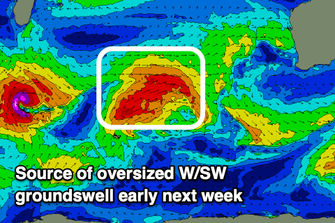
The strengthening north winds will be ahead of a strong, high-riding frontal progression moving in from the west during the week, with it developing south of South Africa tomorrow.
This system will move slowly east through this week generating a fetch of mostly gale-force winds, with severe-gales possible at stages.
The progression is due to move in and across us on the weekend, but a weaker front ahead of it looks to bring strong W/NW tending W winds on Friday, shifting NW-W/NW on Saturday ahead of the system proper and then W/SW to W/NW Sunday as the next system moves in.
Coming back to the groundswell and it looks oversized, with mid-period energy building ahead of it Sunday, with a peak due later Monday and into Tuesday morning.

10-12ft surf is due in the South West with 3-5ft waves across Perth and Mandurah owing to the northward track of the system. Unfortunately winds look to remain onshore and from the N/NW Monday with Tuesday seeing a strong W/SW-SW change.
The persistent onshore winds will be thanks to the next swell generating system firing up to the south-west of us, with this coming from more polar origins before projecting up and over us early-mid next week.
More oversized SW swell is due later week from this source but we’ll have a closer look at this and the local winds which are still up for grabs on Wednesday.

