XL swell for the weekend with workable winds
Western Australian Forecast by Craig Brokensha (issued Friday August 16th)
Best Days: Tomorrow from mid-late morning, possibly Monday morning Perth and Mandurah, Wednesday morning, early Thursday
Features of the Forecast (tl;dr)
- XL W/SW groundswell building tomorrow PM, easing Sun
- Strong N/NE tending weaker E winds in the South West tomorrow AM, strong NE tending variable Perth and Mandurah ahead of a late W/SW change
- Strong SW winds Sun
- Fresh S/SW tending W/SW winds Mon with easing surf, possibly S/SE early Perth and Mandurah
- W/NW winds Tue with small surf
- Large, inconsistent W/SW groundswell Wed with light E/SE tending S/SW winds in Perth Mandurah, S/SE in the South West
- Easing swell Thu with strong E/NE-NE tending N/NE winds
Recap
We saw conditions improve across Perth and Mandurah during the morning yesterday as onshore winds eased and tended more cross-shore along with easing surf from 3ft on the sets. Margs remained poor and onshore.
Today a slim window of early NE winds favoured Perth with average to poor surf elsewhere.
This weekend and next week (Aug 17 - 23)
The weekend ahead will see our XL W/SW groundswell filling in, with the low linked to it currently weakening while projecting north towards Indonesia.

There’s no change to the expected size, with fetches of severe-gale to storm-force winds producing 12ft+ sets into later tomorrow, easing slowly Sunday with 3-5ft waves across Mandurah and 3-4ft sets in Perth.
Winds for tomorrow now look interesting as the remnants of the storm moves towards us in the form of a trough, bringing fresh to strong NE winds to Perth and Mandurah, tending variable and strong N/NE tending E winds across the South West, also tending variable.
This will be then ahead of a late W/SW change.
So with this in mind we should see decent conditions across selected spots tomorrow as the swell builds, with Sunday becoming poor thanks to strong SW winds in the wake of the trough.
Monday looks mostly average with fresh S/SW tending W/SW winds as the weekend swell eases. There’s a chance for S/SE winds early around Perth and Mandurah along with easing 2-3ft sets.
Tuesday looks to be a lay day with fresh to strong W/NW winds, but come Wednesday, winds are due to ease and tend light E/SE-SE across Perth and Mandurah with S/SE winds in the South West along with our inconsistent, long-range W/SW groundswell from the South African region.

The winds generating this swell were again impressive but in our far to medium-range swell window. With this a bit of consistency and size will be lost, with it coming in at 10ft across the South West and 2-3ft in Perth, 3ft Mandurah.
Thursday morning looks decent with freshening E/NE tending NE winds as the swell eases , poor into the afternoon with strong N/NW breezes.
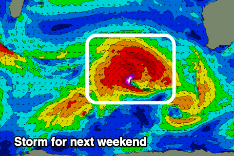
Looking longer term, it looks like a significant frontal progression will fire up to our west, with an XL groundswell likely next weekend but with west winds as the progression moves into us. More on this Monday. Have a great weekend!


Comments
Just noticed the box cam, nice.
The 10 day forecast shows NW to SW winds for 17 August (sat)? Also supported by other forecasts... you reckon NE for Wadjemup?
How's that incoming low through late next week.
Bullseye on the whole west coast.
Shame about the winds with it because it looks like it could be an absolute doozey of a swell maker.