Tricky windows to pick the eyes out of
Western Australian Forecast by Craig Brokensha (issued Monday August 12th)
Best Days: Perth and Mandurah Thursday morning, Perth and Mandurah selected spots early Friday, Saturday as the swell builds, early Sunday
Features of the Forecast (tl;dr)
- Large, close-range W/SW swell today, easing slowly tomorrow and further during the week
- Mod-fresh W/NW winds tomorrow, strengthening from the NW
- Strong W-W/SW winds Wed
- Strong but easing S/SW-SW winds Thu (S/SE early Perth and Mandurah)
- Early N winds Fri, strengthening fromt the N/NW (NE-N/NE esarly Perth and Mandurah)
- Large W/SW groundswell building Sat PM, easing from a similar size Sun AM
- Variable tending N/NW winds Sat
- Strong S/SW winds moving in Sun
Recap
Perth was nice and clean on Saturday morning with 2-3ft sets hanging in the mix, bumpier around Mandurah and poor across Margs.
Yesterday everywhere was onshore along with an afternoon increase in size, holding today but with fresh to strong onshore winds across all regions.

Fun peaks Saturday morning
This week and weekend (Aug 13 - 18)
The first half of this coming week remains poor for surf thanks to persistent onshore winds across all regions, easing and improving across most locations later week, though as you’ll read, some spots will fair better than others.
We’ve got a strong frontal system currently pushing in across the state, with it due to bring some additional large, W/SW swell this afternoon, easing through tomorrow but with moderate to fresh W/NW winds, strengthening from the NW through the day as a small trailing front approaches us.
The front will move across us Wednesday bringing strong W-W/SW winds, shifting more S/SW-SW and easing on Thursday. With this abating trend, Perth and Mandurah should see early S/SE winds before reverting back onshore.

Swell wise, large surf today will slowly ease over the coming days, with Thursday coming in at 2-3ft across the metro locations, easing through the day with onshore 6-8ft surf in the South West.
Friday morning looks smaller and back to 2ft across the metro locations, 4-6ft in the South West and a window of early NE-N/NE winds is expected (more N’th around Margs), strengthening front the N/NW through the day as the next swell producing frontal system approaches.
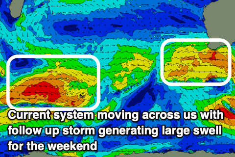
Now, this coming system will originate a little further south in latitude, with a good fetch of gale to severe-gale W/SW winds projecting east towards us. As it approaches though it’s due to take a more south to north alignment, aiming winds as it weakens more towards Indonesia.
Regardless, it’ll have already generated a large W/SW groundswell for the weekend, with it due to fill in strongly Saturday, building to 10ft+ across the South West, 3-4ft in Mandurah and 3ft across Perth later in the day, easing from a similar size Sunday.
It looks like the stalling and northward angle of the final stages of the storm should result in variable offshore winds Saturday morning with N/NW sea breezes as the swell builds, while Sunday looks tricky with the system due to move east, bringing strong SW-S/SW winds at some stage during the morning.
Longer term, another good W/SW groundswell is due into next week but with dicey winds. More on this Wednesday.

