Large, windy swell tomorrow, improving from Friday
Western Australian Surf Forecast by Craig Brokensha (issued Wednesday July 31st)
Best Days: Perth and Mandurah Friday, Saturday all locations, Sunday morning in the South West, Tuesday morning Perth and Mandurah
Features of the Forecast (tl;dr)
- Large W/SW swell tomorrow with strong W/SW-SW winds, easing during the day and possibly become variable in metro regions
- Smaller Fri with E/NE winds Perth/Mandurah, variable in the South West
- Easing swell Sat and Sun with E/NE tending variable sea breezes Sat, E/NE-NE tending N/NE Sun
- Large W/SW groundswell building Tue with strong NW winds (N/NE early Perth and Mandurah)
- Strong W/NW-W winds Wed
Recap
Our XL, W/SW groundswell filled in strongly yesterday but conditions were a bit funky with variable winds tending north across the metro regions, variable all day in the South West.
This morning the winds were into it early out of the north with easing sets, with protected spots fairing best across the metro regions.
This week and weekend (Aug 1 - 4)
We’ve got our large, reinforcing pulse of mid-period swell due tomorrow, generated by a trailing frontal system pushing in on the back of the storm generating yesterday’s swell and with it, we’ll see strong W/SW-SW winds early, easing through the morning.
The South West looks to come in at a messy 10ft with 3-4ft sets in Mandurah, 3ft across Perth.
Friday looks better surf wise with winds easing in the wake of the front, leaving light E/NE breezes across the metro regions, variable across the South West and lumpy.
The swell will be on the ease and down from 6-8ft in the South West, 2-3ft Mandurah and Perth.
The weekend will become cleaner in the South West but with easing surf both Saturday and Sunday. Light E/NE winds are due Saturday with variable sea breezes, E/NE-NE Sunday morning, N/NE into the afternoon.
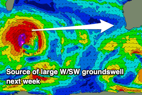
Looking at next week and we’re set to see a return of large W/SW swell energy with winds from the north-western quadrant, generated by a train of mid-latitude lows and frontal systems moving in from South Africa.

An initial strong low looks to generate a fetch of severe-gale to possibly storm-force W/SW winds through our western swell window, generating a large W/SW groundswell for Tuesday, peaking into the afternoon to the 10-12ft range in Margs, 3-4ft Mandurah and 3ft Perth.
Unfortunately the remnants of the storm looks to move in with it, bringing strengthening NW winds (N/NE early metro locations), with strong W/NW-W winds Wednesday as it eases.
Secondary frontal activity looks to generate large, mid-period energy with poor winds Thursday, possibly lighter Friday, but we’ll look at this closer in the next update.

