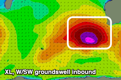
XL groundswell with light winds tomorrow
Western Australian Surf Forecast by Craig Brokensha (issued Monday July 29th)
Best Days: Tomorrow, selected spots Perth and Mandurah early Wednesday, Friday morning
Features of the Forecast (tl;dr)
- XL, W/SW groundswell filling in tomorrow, peaking during the PM, easing Wed
- Variable winds tomorrow, tending E/NE-NE during the AM, then fresher N/NW-NW across Perth and Mandurah into the PM (weaker Margs)
- Strengthening N/NW winds Wed (N/NE early Perth and Mandurah)
- Large, mid-period W/SW swell for Thu PM and Fri AM with strong S/SW tending SW winds Thu, S/SE Fri AM (E to the north)
- Easing swell Sat with winds unknown but likely variable
Recap
It was a poor weekend of surf with building winds and low quality swell.
This morning we’ve seen a window of lighter winds across Perth with bumpy, workable 2-3ft sets while all other locations are choppy and poor.
This week and weekend (Jul 30 - Aug 4)
These notes will be brief today as Steve covers the Olympic surfing event.
The coming period revolves around the XL groundswell due into tomorrow, with a significant cold outbreak projecting severe-gale to storm-force W/SW winds towards us, through our western swell window.
The storm is currently south-west of us, moving east while weakening, with an XL long-period W/SW groundswell due to peak tomorrow afternoon across the state.

The South West looks to come in at 15ft+ across the South West with 4-5ft+ surf in Mandurah, 3-4ft across Perth.
An easing trend is then due into Wednesday, dropping back from the 10ft range across Margs, 3-4ft Mandurah and 2-3ft Perth.
Looking at the local winds and we’ll see the current swell producing storm drifting south-east, allowing winds to ease and tend variable across all locations. With this, variable E/NE-NE winds are due across most locations tomorrow, shifting N/NW-NW into the afternoon, fresher across Perth and Mandurah.
This freshening wind will be thanks to a trailing front pushing up and towards us, bringing with it strengthening N/NW winds Wednesday (N/NE early Perth and Mandurah) as the swell eases.
The trailing front should generate a large, but weaker mid-period W/SW swell for Thursday afternoon and Friday morning, with a broad but mostly fetch of strong W/SW winds being aimed towards us.
The South West looks to reach 8ft later Thursday and Friday morning, 3ft in Mandurah and 2-3ft across Perth but with strong S/SW tending SW winds on the former (as the swell generating front clips us), with Friday likely seeing E’ly offshores across Perth and Mandurah, S/SE in Margs.
Winds for Saturday are dicey thanks to a lingering trough in the region but the swell looks to keep easing.
Longer term we’re looking at a period of smaller surf with light morning winds, with some new, distant W/SW groundswell pulses for next week.
More on this Wednesday and Friday.

