Make the most of today
Western Australian Surf Forecast by Craig Brokensha (issued Friday July 26th)
Best Days: Today, selected spots Tuesday and Wednesday morning
Features of the Forecast (tl;dr)
- Easing surf tomorrow with N/NE tending stronger N/NW winds
- Large building W'ly swell Sun PM with strong N-N/NW tending NW winds
- Strong W/NW winds Mon (possibly lighter N/NE around Perth for a period)
- XL W/SW groundswell building late Mon, peaking Tue with light-mod N/NE tending fresher N/NW winds
- Easing swell Wed with strong N/NE tending N/NW winds
- Large, reinforcing W/SW swell Thu with W winds
Recap
Poor surf in the South West with onshore winds across Perth and Mandurah as well yesterday, much better today and on the improve with a weak, easing swell but cleaner conditions.
Margs is easing from 6ft with lumpy but fun conditions, 2ft+ in Perth and Mandurah. It should continue to improve as winds go variable into the afternoon.
This weekend and next week (Jul 27 - Aug 2)
Make the most of today as the weekend looks poor. Morning N/NE winds and a smaller swell tomorrow will give into a strengthening N/NW’ly through the afternoon, with strong N-N/NW tending NW winds on Sunday as some new mid-period W’ly swell arrives.
This swell now looks a little larger, with the mid-latitude frontal system linked to it now due to generate a stronger burst of gales on approach to us this weekend.
A late pulse to 6ft+ is due in the South West, peaking Monday morning to 6-8ft with 2-3ft sets to the north.
Unfortunately strong W/NW winds will persist into Monday morning, though easing in strength through the day, while there’s an outside chance for lighter N/NE winds in Perth early.

Into the afternoon we should see the swell start to uptick in size further, ahead of an XL W/SW groundswell on Tuesday.
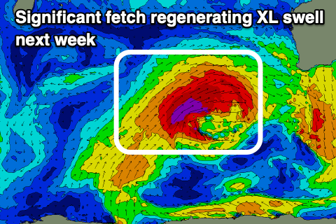
The source will be a significant cold outbreak projecting up into the Indian Ocean over the coming days.
The strength of this progression has been upgraded with a great, elongated fetch of severe-gale W/SW winds along with embedded storm-force winds due to move towards us over the weekend.
The swell looks significant with a peak Tuesday to the 15ft+ range in the South West, 4-5ft Mandurah and 3-4ft across Perth.
Winds are tricky and not ideal for a lot of spots, but should be better than Monday. Light, morning N/NE winds will shift N/NW and increase during the day, with Wednesday becoming poor as the swell eases under stronger N/NE tending N/NW winds.
This will be ahead of another, smaller swell generating front on the tail of the activity on the weekend, producing a reinforcing W/SW swell for Thursday to 8ft+ in the South West and 2-3ft to the north.
Unfortunately strong W’ly winds will accompany the swell with a final front moving up and across us.
A drop in the frontal activity is due later next week, allowing winds to slowly improve into Friday but more so next weekend but with smaller surf. More on this Monday. Have a great weekend!

