A couple of windows to pick the eyes out of
Western Australian Surf Forecast by Craig Brokensha (issued Wednesday July 24th)
Best Days: Friday morning, Tuesday morning, early Wednesday
Features of the Forecast (tl;dr)
- Moderate to large sized mid-period SW swell peaking this afternoon, easing tomorrow with strong W/SW winds
- Easing swell Fri with light E/SE-E/NE winds ahead of sea breezes
- Small Sat with strengthening N/NE tending N/NW winds
- Moderate + sized mid-period W swell building Sun with strong N/NW tending W/NW winds
- Mix of swells Mon with strong W/NW tending W winds, then easing
- XL W/SW groundswell likely peaking Tue with variable morning winds from the north-eastern quadrant
- Easing swell Wed with N/NE tending strong NW winds
Recap
The surf was average across all locations at dawn yesterday but improved through the morning with winds tending cross-offshore along with an easing W/SW swell.
This morning we’ve got smaller surf and onshore winds were back in across the South West, more variable to the north with peaky 2ft+ sets. Conditions will deteriorate across metro locations as winds strengthen from the W/SW.
This week and weekend (Jul 25 - 28)
This afternoon’s strengthening W/SW winds are linked to a relatively weak frontal system clipping the state and we’ll see these winds persist tomorrow as a secondary system moves in.
Swell wise, a new pulse of mid-period SW swell that’s currently on the build will peak later and start easing tomorrow as local windswell takes its place.
Into Friday the frontal activity will clear allowing winds to swing offshore from the E/SE-E/NE across all locations but we’ll be looking at weak, easing levels of mid-period W/SW-SW swell from 5-6ft in the South West and 2ft to the north.
Even though weak, this window is worth making the most of as the weekend will become poor thanks to a further drop in swell along with strengthening N/NE tending N/NW winds Saturday, stronger N/NW tending W/NW on Sunday.
Swell wise, some new mid-period W’ly swell is due to build through the day Sunday, generated by an elongated low forming south-east of Madagascar and then traversing slowly east while generating various bursts of strong W’ly winds.

It looks moderate + in size with sets due to build to 6ft later in the day across the South West, 2ft to the north along with some localised NW windswell.
Early Monday looks to come in at a similar size, but with strong W/NW tending W winds.
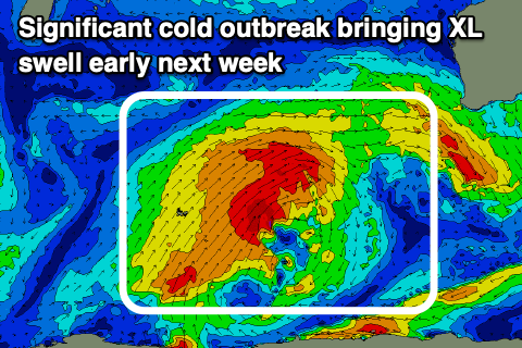
Into the afternoon but more so Tuesday, we’ve got some XL W/SW groundswell due across the region, generating by a significant cold outbreak firing up on the tail of the mid-latitude low.
Various fetches of gale to severe-gale-force winds projecting up, one on top of each other should produce a significant spike in size Tuesday along with easing and possibly variable morning winds.
The timing if the peak in size and local winds is still up for grabs with the major forecast models coming in divergent so we’ll have to have another look at it on Friday. At this stage the South West looks to come in at 12-15ft, 4ft in Mandurah and 3ft+ across Perth but check back Friday and Monday.

