Poor outlook for the South West
Western Australian Surf Forecast by Craig Brokensha (issued Monday July 22nd)
Best Days: Protected spots tomorrow morning all locations, Wednesday morning Perth and Mandurah (possibly also Thursday morning), Friday morning for the keen in Perth and Mandurah
Features of the Forecast (tl;dr)
- Easing surf tomorrow with moderate to fresh S/SE winds, tending S-S/SW
- Moderate + sized mid-period SW swell filling in Wed, peaking into the PM
- Strengthening W/SW-SW winds Wed, lighter E/NE-NE during the AM in Perth/Mandurah)
- Easing swell Thu with strong W/SW winds (possibly variable early to the north)
- Smaller Fri with fresh W/SW winds (variable early to the north)
- Small Sat with fresh W/NW winds, N/NE to the north
- Large W/SW swell Mon with NW winds, posssibly N/NE to the north
Recap
Terrible conditions and surf over the weekend with winds out of the western quadrant and large levels of swell, a little more doable this morning across metro locations.
This week and weekend (Jul 23 - 28)
Unfortunately we’re entrenched in a poor, onshore flow and it’s set to continue for at least the coming fortnight thanks to a persistent node of the Long Wave Trough sitting within our vicinity.
This upper level disturbance will effectively steer and strengthen frontal systems up and into us, bringing lots of swell but also lots of onshore wind.
The Margaret River region will suffer the most, with windows of lighter winds and cleaner conditions expected across more northern regions throughout the period.

Looking at tomorrow, and there’s a window for protected spots expected in the South West as a trough brings a S-S/SE change early tomorrow morning, moderate to fresh in strength before swinging back more S/SW-S through the afternoon.
Size wise, the current oversized W/SW groundswell is due to ease, with dropping sets from the 8ft range across exposed breaks due tomorrow (6-8ft mostly), 2-3ft in Mandurah and 2ft+ across Perth.
The next approaching front looks to bring strengthening W/SW-SW winds on Wednesday that will be variable offshore across Perth and Mandurah (E/NE-NE) during the morning but with small, weak leftovers.
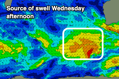
During the afternoon, a new pulse of mid-period SW swell is due, generated by a relatively weak frontal system that’s currently south-west of us. A fetch of strong W/SW-SW winds should generate a kick back to 6-8ft in the South West during the day, 2ft to possibly 3ft in Mandurah after lunch and 2ft in Perth (but with onshore winds).
Thursday looks to see easing swell along with strong W/SW winds across most locations, possibly tending variable in Perth early but we’ll confirm this in Wednesday’s update.
Similar, gusty onshore W/SW winds are due to continue into Friday, with variable winds likely in the morning across Perth but with a small 2ft of swell.
Into the weekend we’re looking at smaller surf with lingering W/NW winds in the South West, N/NE to the north but tiny.
Sunday will also be poor with a low point in swell and strong N/NW tending W/NW winds ahead of a shallow W/SW change.

The surf should then come up again into Monday, thanks to a strengthening mid-latitude frontal system approaching from the west, bringing a good fetch of prefrontal, strong to gale-force W/NW winds through our western swell window.
A large mid-period W/SW swell is expected, with it peaking in the 10ft range across the South West, 2-3ft in Mandurah and 2ft+ across Perth but with strengthening N/NW winds, likely N/NE early for a period to the north.
It looks like north-west winds will continue through next week with further frontal activity bringing various pulses of large to oversized swell from the W/SW and SW. More on this in the coming updates.

