Great today and tomorrow with easing surf
Western Australian Surf Forecast by Craig Brokensha (issued Friday July 12th)
Best Days: Today, tomorrow, Sunday in the South West, selected locations Wednesday
Features of the Forecast (tl;dr)
- Large S/SW groundswell peaking today (PM Perth and Mandurah) with offshore tending variable winds
- Easing swell tomorrow with mod-fresh E-E/NE tending lighter NE winds
- Smaller Sun with strong E/NE winds (tending N/NE to the north)
- Small Mon with E/SE tending variable winds
- Inconsistent long-range W/SW groundswell building Tue with strengthening NE tending N/NE winds
- Large W/SW-SW groundswell Wed with strong N/NE tending N winds
- Easing swell Thu with SW winds
Recap
Perth and Mandurah saw improving conditions through yesterday with light winds out of the north-east and some fun westerly swell coming in around 3ft on the sets. Perth was the standout while further south, conditions deteriorated with Margs performing worst.
Today we’ve got a large new S/SW groundswell in the water with it due to build to the north through the day under light light offshore winds that should tend variable into the afternoon. Margs is lumpy but should improve as the day goes on.
This weekend and next week (Jul 13 - 19)
Today’s large S/SW groundswell was generated by a strong polar frontal progression that fired up south-west of us the last couple of days.
The system has since cleared to the east allowing winds to improve across the South West. Size wise we should see a peak in the 10ft+ range across Margaret River with 3ft sets across Mandurah into the afternoon and 2-3ft waves in Perth after lunch.
Winds are due to go variable, with the swell easing back tomorrow from 6-8ft, 2-3ft and 2ft respectively from Margs to Perth and with a moderate to fresh E-E/NE offshore, tending variable NE into the afternoon.
Sunday will be smaller and with strengthening E/NE tending N/NE winds across the north as a small low forms west of us.

This low will be short-lived and be whisked away to the north Sunday evening, leaving E/SE winds into Monday morning.
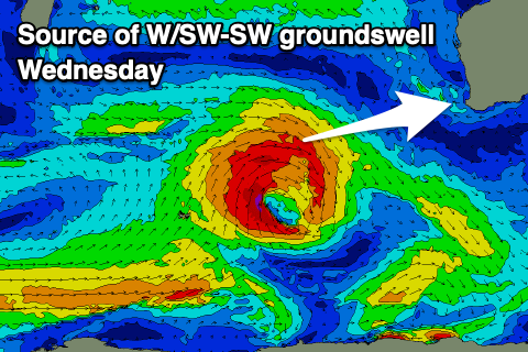
Now into Tuesday afternoon and more so Wednesday, we’ve got a mix of inconsistent W/SW groundswell generated by a distant storm that fired up under South Africa, while some better, closer range groundswell energy is due on top, produced by a strong low firing up to the north of the Heard Island region on the weekend.
A fetch of gale to severe-gale W’ly winds will be projected towards us, weakening and then followed by a less favourably aimed fetch of S/SW gales. This should generate a large W/SW tending SW groundswell peaking Wednesday to 8ft across the South West, 2ft to possibly 3ft in Mandurah and 2ft across Perth.

Conditions will start to deteriorate Tuesday as winds freshen from the NE tending N/NE with the new, small groundswell, while Wednesday will unfortunately see strong N/NE tending N winds.
The strengthening winds will be ahead of an approaching trough, with no new swell to follow, but behind this a much more significant cold outbreak is likely next weekend.
A high projecting polar frontal progression looks to generate a large to possibly extra-large swell but we’ll have a closer look at this next week. Enjoy today and have a great weekend!


Comments
Thanks for getting these up early, Craigos