Average couple of days, large swell later in the week
Western Australian Surf Forecast by Craig Brokensha (issued Monday July 8th)
Best Days: Keen surfers Perth and Mandurah Thursday morning, Friday morning, Saturday morning, Sunday morning in the South West, next Tuesday morning
Features of the Forecast (tl;dr)
- Strengthening N/NW tending W/NW winds tomorrow with a building windswell
- Oversized mid-period W swell for Wed AM, easing with strong SW winds, slowly easing
- Easing surf Thu with fresh SW winds, variable early to the north
- Large S/SW groundswell Fri, peaking through the day, easing Sat
- S/SE-SE tending SW winds in then South West Fri, E/NE to the north in the AM
- Easing swell Sat with E tending SW winds
Recap
Following the epic surf seen mid-late last week, the weekend was a write-off with a low point in swell Saturday under strengthening north-northeast winds, choppy and onshore yesterday.
Today we’ve got a continuation of onshore winds in the South West with some new W’ly swell while Perth and Mandurah were fun early with peaky 2-3ft sets. Winds are now freshening again out of the north, creating deteriorating conditions.
This week and weekend (Jul 9 - 14)
Looking at the week ahead and we’ve got an oversized, low quality W’ly swell due to build over the coming days thanks to a high riding frontal progression pushing up and across us.
Winds will strengthen from the N/NW and tend W/NW through tomorrow as the system moves across us, with building levels of windswell, peaking Wednesday morning with a bit more period as winds shift SW, strong in the morning and slowly easing through the day.
The swell will be smaller Thursday as onshore winds linger in the South West, N/NE-NE early to the north.
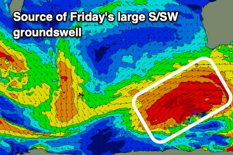
The swell generated by the high riding front isn’t overly special, but a more significant Southern Ocean frontal system projecting up on its tail should generate a larger, stronger S/SW groundswell for Friday.

A broad fetch of W/SW gales should project up through our southern swell window before moving further east, under the country and out of our swell window.
Size wise, 10ft+ surf is due in the South West, 3ft+ across Mandurah on the magnets and 2-3ft in Perth.
Winds on Friday look much better and E/NE across Perth and Mandurah during the morning, S/SE-SE in the South West ahead of weak sea breezes, with Saturday coming in much cleaner across Margs with an E’ly offshore. The swell will be on the ease, likely from 8ft.
The swell will continue to fade Sunday with clean conditions throughout the morning while our next swell looks to arrive Tuesday, that being a long-period W/SW groundswell. More on this Wednesday.

