Poor weekend, XL, stormy swell next week
Western Australian Surf Forecast by Craig Brokensha (issued Friday July 5th)
Best Days: Today, early Monday selected locations Perth and Mandurah, Thursday morning Perth and Mandurah, Friday morning, Saturday morning in the South West
Features of the Forecast (tl;dr)
- Fading swell tomorrow with strong NE tending N/NE winds
- Strong W/NW tending W/SW winds Sun with a moderate + sized building W swell
- Easing W swell Mon with strengthening N/NW winds and some building N/NW windswell (NE winds early Perth and Mandurah)
- Strong N tending W/NW winds Tue with a stormy, building swell
- XL stormy W'ly swell Wed with strong to possibly gale-force W-W/SW winds
- Easing swell Thu with strong but easing SW winds, likely tending S/SE Perth and Mandurah
- Further drop in size Fri with SE tending S/SW winds
- Smaller Sat with E/SE tending S/SW winds
Recap
The surf still pumped through yesterday but was nothing compared to Wednesday’s day of days with smaller surf in the 8ft+ range across the South West and 2-3ft further north.
This morning we’ve got smaller 2ft leftovers across the metro locations with surf in the 6ft range across the South West with gusty offshore winds that will tend shift more NE into the afternoon.
This weekend and next week (Jul 6 - 12)
Following the last couple of days of excellent surf, the weekend looks windy and poor with strengthening NE tending N/NE winds tomorrow along with smaller, fading surf.
This will be ahead of a strong W/NW tending W/SW change on Sunday, bringing with it a small increase in local swell during the afternoon and Monday morning before easing..
Winds will persist out of the N/NW-NW and strengthen Monday, but metro locations should see a morning NE’ly with peaky 2ft+ sets (2-3ft Mandurah).
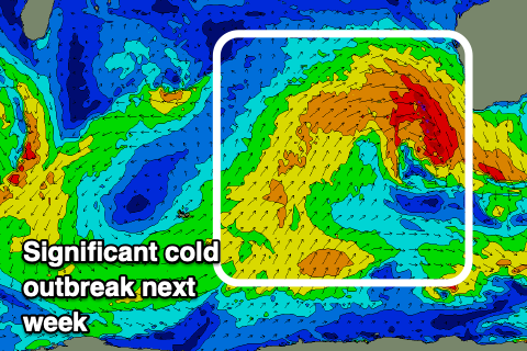
A more significant frontal progression will push up and into us through the middle of the week, with it projecting north of the Heard Island region through Sunday and then east towards us through early to mid-week.

Wind speeds aren’t overly significant but the breadth and width are still impressive, with stormy, extra-large surf due to develop into Wednesday but with strong W’ly winds that may near gale-force in certain regions.
We’re looking at stormy 12-15ft surf across the South West, 4-6ft Mandurah and 3-5ft Perth, easing back through Thursday with rapidly easing SW winds. Perth and Mandurah could see early S/SE winds and solid, but easing surf, still a mess in the South West.
Cleaner conditions are due into Friday but the South West will take a while to fully clean up, likely best next Saturday but way smaller.
Longer term the outlook is slower following this big cold outbreak so try and work the improving, down side later next week. Have a great weekend!

