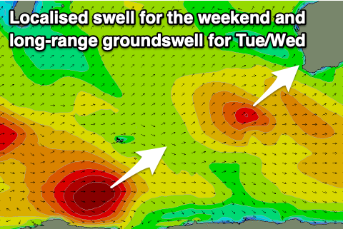
Workable weekend but with a weak swell, OK early next week
Western Australian Surf Forecast by Craig Brokensha (issued Friday June 21st)
Best Days: Sunday protected spots, Monday morning for the keen, Tuesday ahead of the wind, Thursday morning
Features of the Forecast (tl;dr)
- Weak, large localised SW swell building tomorrow, peaking Sun AM, easing
- Strong SW winds tomorrow, tending S/SE Sun, gusty to the south
- Fading swell Mon with E/SE winds ahead of sea breezes
- Inconsistent, moderate sized SW groundswell building Tue, peaking into the PM, easing Wed
- Moderate E/NE tending strong N/NE winds Tue, strong N/NW tending W/NW Wed
- Moderate sized mid-period swell for Thu with E tending S/SE winds
Recap
The surf was great yesterday morning with easing levels of swell from Wednesday though still to 6-8ft in the South West and 2-3ft to the north, smaller this morning with an early window of OK conditions which have now gone to crap with strengthening northerly winds.
This weekend and next week (Jun 22 - 28)
Today’s strengthening winds are prefrontal northerlies ahead of a small low pressure system that’s pushing up and into us on the weekend.
The low isn’t overly strong and as a result the swell will be low period and weak, though still in the large size range later tomorrow but more so Sunday morning.
A low quality 8ft wave is due across the South West, with 3ft waves in Mandurah, 2-3ft Perth, easing through Sunday.

Strong SW winds are due tomorrow with winds now due to shift S/SE across all locations on Sunday as the low clears east, though being gusty across the South West.
Monday looks cleanest with a morning E/SE offshore but weak, easing sets from 3-5ft max in the South West, 1-2ft to the north, if that.
Into Tuesday, an inconsistent SW groundswell is due, generated by a short-lived fetch of gales around a polar low to the west of the Heard Island region.
No major size is due to the north with inconsistent 4-6ft sets due into the afternoon across the South West into the afternoon, easing Wednesday.
Winds will be favourable early Tuesday and E/NE but strengthen from the N/NE into the afternoon with stronger N/NE winds Wednesday morning ahead of a W/NW change.
This will be as a mid-latitude low moves in and across us, though the swell generating properties of it are poor. The main fetch will be more aimed into the Indian Ocean rather than us, with it moving across us Thursday, swinging winds quickly around to the E-S/SE but with no major size. We’ll confirm this Monday though.
Longer term the Indian and Southern Ocean remain void of any major frontal activity resulting in smaller swells with morning offshore winds for the South West. More on this Monday. Have a great weekend!

