Fun, easing surf, windy and building on the weekend
Western Australian Surf Forecast by Craig Brokensha (issued Wednesday June 19th)
Best Days: Today, selected spots tomorrow, Perth and Mandurah Sunday morning, Monday morning all locations, Tuesday morning in the South West
Features of the Forecast (tl;dr)
- Easing swell tomorrow with fresh E/NE tending NE then N/NE winds
- Smaller Fri, with a moderate sized SW swell for the PM
- Strengthening N/NE tending N winds (N/NW in the South West later) with a building N/NW windswell
- Large, mid-period SW swell building Sat, peaking Sun AM, easing
- Strong S/SW tending SW winds Sat, S/SW Sun (S/SE early Perth and Mandurah)
- Easing swell Mon with gusty S/SE winds
- Smaller Tue with E tending SW winds
Recap
Metro locations continued to offer fun surf yesterday with decent winds early and 2ft of swell while the South West was choppy and onshore.
Today the frontal system linked to yesterday’s change has cleared to the east and we’ve got large, building surf with cleaner conditions, coming in at 10ft across the South West, 3ft in Mandurah and 2ft+ across Perth.
The South West should continue to improve through the day as winds remain favourable and tend E/NE-NE.

Large new swell in the water today
This week and next (Jun 20 - 28)
Today’s swell will back off through tomorrow and winds will be favourable for selected spots with a moderate to fresh E/NE tending NE breeze, then N/NE into the afternoon.
Perth and Mandurah look to ease back from 2ft (odd bigger one Mandurah) with Margs dropping from 6ft to occasionally 8ft.

Friday will be initially smaller and with less favourable, strengthening N/NE tending N winds (N/NW in the South West) along with some localised, building N/NW windswell. During the day some new mid-period SW swell spreading off a W/NW fetch is likely but only to 4-5ft or so.
The strengthening winds will be associated with the next swell generating system pushing up towards us, with it being downgraded a touch since Monday.
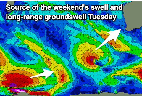
The storm will be a low pressure system, with strong winds projected up and across us on Saturday, moving slowly east on Sunday. Secondary fronts on its tail will slow the improvement in winds as the low clears, with strong S/SW tending SW winds on Saturday due to linger from the S/SW into Sunday (early S/SE Perth and Mandurah), tending S/SE across all locations on Monday but remaining gusty.
Swell wise, large, mid-period energy is due to build Saturday, peaking Sunday morning in the 10ft range across the South West, 3ft Mandurah and 2-3ft in Perth, with those early S/SE winds.
Monday looks smaller and weaker as the winds try and improve across the South West, cleaner Tuesday, with an inconsistent SW groundswell in the mix but with better E offshore winds.
The South West will be the pick with inconsistent 3-5ft surf, tiny to the north.
Longer term the outlook is a bit meh thanks to no consolidated Southern Ocean storms moving through our swell window. Instead we’re looking at mid-latitude activity that will break and project more towards the Maldives. More on this Friday.

