Poor end to the week, much better Sunday
Western Australian Surf Forecast by Craig Brokensha (issued Wednesday December 20th)
Best Days: Keen surfers Friday morning in the South West, Sunday ahead of sea breezes, Monday morning in the South West
Features of the Forecast (tl;dr)
- Small, mid-period SW swell building tomorrow afternoon, peaking Fri AM with E/SE-SE tending S/SW winds
- Smaller Sat with strong S/SE winds
- Moderate sized + SW groundswell Sun, possibly undersized early with fresh to strong but easing E/SE winds ahead of sea breezes
- Easing swell Mon with SE tending S/SW winds
- Strong S/SE tending S/SW winds on Tue, similar Wed with small levels of localised swell
- Small, background mid-period swell Thu with fresh SE tending strong S/SW winds
Recap
Monday's swell eased back steadily as expected with dropping 4-5ft sets across the South West magnets early yesterday, down to 3ft today. Strong morning offshore winds slowly abated before later sea breezes kicked in. Perth and Mandurah were small to tiny yesterday morning, tiny today.
This week and next (Dec 21 - 29)
Tomorrow morning will be smaller again ahead of some small, new mid-period SW swell energy into the afternoon, peaking Friday morning.
No major size is due with 3ft to possibly 4ft sets on the South West magnets, tiny to the north.
Conditions should be clean tomorrow with an E/SE-SE offshore ahead of strong sea breezes, similar Friday morning with the small bump in swell.
Saturday looks smaller and with less favourable, stronger S/SE winds, while into Sunday we've got our new, inconsistent SW groundswell due.

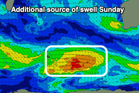
There's been no change to the expected timing but a slight upgrade in the size, with the swell generated by a burst of gales, west of the Heard Island region. The remnants of this storm will generate some additional strong to gale-force W/SW winds east of the Heard Island region this evening and tomorrow.
This should help boost the peak of the swell slightly above Monday's expectations, with Sunday due to build to 5-6ft across the South West (undersized early), easing slowly Monday, with building 1-2ft sets in Mandurah, 1-1.5ft in Perth.
Conditions still look great for Sunday morning with a fresh to strong but easing E/SE morning breeze giving into strong sea breezes early afternoon.
Weaker SE winds are due on Monday as the swell starts to slowly ease, with poor, strong S/SE -S/SW winds due to kick in from Tuesday thanks to a small trough sliding up towards us early week.
This will bring some low quality windswell to the metro regions through the afternoons, easing each following morning but with cross-shore winds.
It looks like winds will start tipping back more SE into Thursday/Friday along with moderate levels of background SW swell energy. None of it is overly sizey but check back here on Friday for any changes to the outlook.

