Fun swells with funky winds
Western Australia Surf Forecast by Craig Brokensha (issued Wednesday February 15th)
Best Days: Tomorrow morning in the South West, Saturday morning in the South West and Mandurah, protected spots Monday morning in the South West and Mandurah, Tuesday morning in the South West
Features of the Forecast (tl;dr)
- Easing surf tomorrow with a reinforcing mid-period SW swell for the PM
- Variable tending gusty W winds tomorrow (SE in Perth and Mandurah)
- Moderate sized SW swell building Fri, peaking in PM with variable S tending strong SW winds
- Easing surf Sat with E/SE tending strong S/SW winds
- Smaller Sun with strengthening S/SE winds
- Moderate sized + SW groundswell for Mon AM with strong S/SE winds, easing Tue with a morning SE breeze
Recap
Less than ideal conditions with building surf through yesterday, cleanest and best this morning before the swell lost too much size. Protected spots were the best in the South West with easing 6ft+ surf, 2ft in Mandurah and Perth.
This week and next (Feb 14 - 24)

Looking at the coming days and the size from yesterday and this morning will continue to ease into tomorrow but some reinforcing mid-period SW swell will stop the swell easing further through the day.
This is being generated by a broad but weak fetch of W/SW winds moving under us today, with sets to 4-5ft due to continue across the South West, 1-1.5ft to the north.
A secondary slightly stronger front pushing through, on top of the active sea state generated by the first should generate a good SW swell for Friday, building through the day and peaking into the afternoon.
Sets to a better 5-6ft should develop in the South West, with small, slow 1-2ft sets across Mandurah, 1-1.5ft in Perth, easing Saturday from 4-5ft+ and 1-1.5ft respectively.
Locally winds will favour Perth and Mandurah tomorrow, SE in the morning, while Margs could be decent with variable winds but possible some local lump. The afternoon will be poor everywhere with gusty W winds.

Friday looks to see variable S'ly winds ahead of strong SW sea breezes, great Saturday morning with an E/SE offshore across all locations.
A trough will unfortunately bring stronger S/SE winds on Sunday as the swell eases a little more.
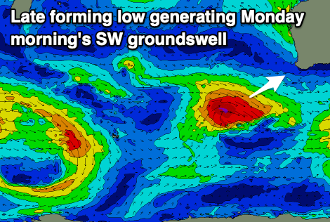
Moving into early next week and a strong low is due develop south of us on Saturday, too late to generate any decent swell unfortunately. We should see some groundswell spreading up radially for the South West from a pre-frontal fetch of strong W/NW winds, arriving Monday morning and offering surf to 5-6ft across the South West, 1-2ft in Mandurah and 1-1.5ft across Perth.
Winds will unfortunately remain strong from the S/SE, favouring protected spots, with cleaner conditions Tuesday with a SE breeze as the swell eases.
We'll see the swell ease back through the week ahead of a flurry of healthy frontal activity in the Southern Ocean through Sunday and Monday. This should generate some good swell from late next week but we'll have a closer look at this on Friday.

