Poor tomorrow, improving from the middle of the week
Western Australia Surf Forecast by Craig Brokensha (issued Monday February 13th)
Best Days: Wednesday morning protected spots, Thursday morning in the South West, Friday morning in the South West, Saturday morning
Features of the Forecast (tl;dr)
- Large SW groundswell building tomorrow with fresh S/SW winds, strengthening
- Easing SW groundswell Wed with S/SE tending strong S/SW winds
- Smaller Thu with E/SE tending strong S/SW winds
- Building mid-period swell Fri with variable tending S/SW winds
- Moderate sized mid-period SW swell peaking Sat with SE tending S/SW winds
- Easing surf Sun with strong S/SE winds
Recap
Fun conditions with clean 3-4ft waves across the South West on Saturday with a mix of mid-period swells. Our better pulse of mid-period energy for Sunday came in on forecast with great conditions and clean 5-6ft waves in the South West. There were plenty of options before sea breezes kicked in, smaller today and to 4-5ft but nice and clean again.
Mandurah and Perth were tiny on Saturday but much better yesterday with clean 2ft sets, back to a tiny 1-1.5ft today.

Fun sized sets this AM
This week and weekend (Feb 14 - 19)
I hope you've made the most of the cleaner conditions and fun sized swells across the region since the weekend, as we're set to see conditions deteriorate over the coming days as a flurry of weak mid-latitude fronts push up and under us, clipping the state.
The first will move through around dawn tomorrow, bringing a fresh and gusty S/SW breeze to all locations, spoiling a new, large building SW groundswell.
This swell was generated by a great polar low that formed south-east of the Heard Island region, producing a fetch of severe-gale W/SW winds in our medium-range swell window.
The low weakened around the Heard Island region and we'll see inconsistent sets to 8ft building into tomorrow afternoon, 2ft to occasionally 3ft in Mandurah and 2ft across Perth.

Easing surf is due Wednesday and there's a window of favourable S/SE winds due across all locations with sets dropping from 6ft+ in the South West, 2ft in Mandurah and 1-2ft across Perth before S/SW sea breezes kick in.
Thursday looks a bit cleaner again with a light E/SE offshore in the South West, S/SE further north as the swell eases further.
The South West should still be fun and in the 4ft range.
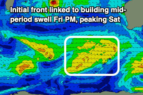
From Friday afternoon but more so Saturday, we should see a renewal of mid-period SW swell thanks to a broad but weak frontal progression firing up to our south-west tomorrow.
An initial front will be followed a secondary slightly stronger system, but a little less favourably aligned. This swell will favour the South West, coming in at a fun 5-6ft on the sets, 2ft in Mandurah and 1-2ft across Perth.
A morning SE breeze should create clean conditions across all locations Saturday morning ahead of sea breezes with less favourable S/SE tending strong S/SW winds on Sunday as the swell eases.
Longer term the swell will ease into the middle of the week with a possible decent swell due later week but the models aren't quite in alignment regarding this. More on this Wednesday.

