A couple of fun swells with workable winds
Western Australia Surf Forecast by Craig Brokensha (issued Monday December 5th)
Best Days: Protected spots tomorrow, Wednesday morning, Saturday morning protected spots, Sunday morning
Features of the Forecast (tl;dr)
- Moderate-large S/SW groundswell building tomorrow, peaking in the PM, easing Wed
- Strong S/SE winds tomorrow (possibly S/SW later PM Perth and Mandurah)
- Strong, easing E/SE winds ahead of sea breezes Wed
- Smaller Thu with S/SE tending S/SW-SW winds, persisting Fri
- New moderate sized mid-period SW swell building Fri, peaking Sat with a secondary stronger pulse
- S/SE-SE tending S/SW winds Sat, E/SE-SE Sun AM
Recap
Saturday's swell came in a little better than expected across the South West with clean conditions and 5-6ft sets on the exposed reefs. Perth and Mandurah were smaller and 1-1.5ft early, building through the day but poor into the afternoon with sea breezes.
A drop in swell was seen through Sunday but Perth saw better 1-2ft waves through the morning.
Today the swell is smaller and clean again but without any major size.

Saturday AM
This week and weekend (Dec 6 - 11)
The coming days look to be the best of the coming period, with a new S/SW groundswell expected to fill in tomorrow, peaking through the afternoon, then easing Wednesday.
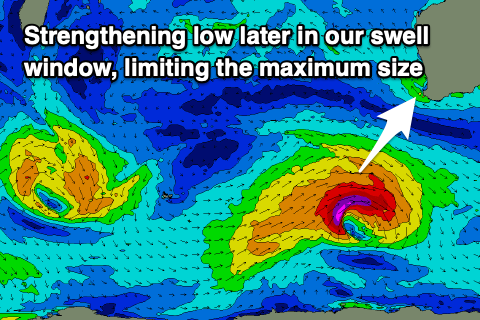
The source of this swell was a strong low firing up to our south-west on the weekend, deepening while moving east and more into our southern swell window.

An initial fetch of gales reached severe-gale in strength, and we should see a moderate-large S/SW groundswell from this low, building to 6ft in the South West on the sets (I wouldn't be surprised if there was the odd bigger one), 2ft in Mandurah and 1-2ft across Perth.
Winds tomorrow aren't ideal as a deepening heat low inland squeezes a high to our south-west, bringing strong S/SE winds that will persist most of the day. Perth and Mandurah may see late S/SW breezes, though conditions will be choppy and bumpy regardless.
Easing surf from 5-6ft and 1-2ft respectively is due on Wednesday along with a strong, easing E/SE offshore and strong afternoon sea breezes.
Thursday will be smaller and winds will deteriorate as the low starts to move east, bringing S/SE tending strengthening S/SW-SW winds as we fall under its western flank.
Unfortunately it looks like onshore S/SW-SW winds will continue through Friday along with the arrival of a small, new mid-period SW swell.

This swell and another for Saturday will be generated by a broad but weak low moving through our swell window over the coming days. Strong, pre-frontal W/NW winds will be followed by a better aligned fetch of W/SW winds, producing two seperate pulses of swell for Friday and Saturday respectively.
Saturday's looks best with surf to 5-6ft across Margs, 2ft in Mandurah and 1-2ft across Perth. We'll likely see winds shift S/SE-SE into Saturday morning ahead of sea breezes, with easing surf and a SE-E/SE offshore Sunday morning.
Following this swell there's nothing too major due into early next week so make the most of the coming windows of swell and offshore winds.

