Poor outlook ahead
Western Australia Surf Forecast by Craig Brokensha (issued Wednesday November 30th)
Best Days: Saturday morning, protected spots Sunday morning in the South West
Features of the Forecast (tl;dr)
- New S/SW groundswell for later Wed, easing Thu with strong S/SW winds in the South West, easing slightly and moderate-fresh W/SW-SW winds in Perth and Mandurah
- Smaller Fri with S/SE tending strong S/SW-SW winds
- Small mid-period SW swell building Sat (peaking in the PM) with moderate S/SE-SE tending strong S/SW winds
- Easing surf Sun with strong S/SE winds
- Small Mon with SE tending S/SE winds
- Small swell Tue with strong S/SE-SE winds
Recap
Windy, clean conditions across the South West yesterday morning with a building swell that reached 4-6ft just before sea breezes kicked in later morning. Mandurah and Perth were clean but tiny, while this morning we've got hot conditions and offshore winds with a bit of north in them and infrequent 1-2ft sets in Mandurah with 1-1.5ft surf across Perth.
Margs was a little funky with the offshore winds only now influencing the surf, along with a drop in size back from 4-5ft or so.


Windy, building surf yesterday AM
This week and next week (Nov 31 – Dec 9)
A developing heat low off the coast today is the reason for the conditions across the state this morning, but winds have now gone N/NW across Mandurah and Perth as the low starts to drift south-east across the state.
This will bring fresh to strong S/SW winds to the South West tomorrow morning, a touch weaker and W/SW winds to the north, spoiling a secondary pulse of S/SW groundswell in the South West.

A high is due to move in behind the low on Friday, swinging winds to the S/SE along with smaller, easing surf.
Looking at tomorrow's and Friday's size, the source of the S/SW groundswell was a late forming but strong low in our southern swell window, with sets expected to ease from 6ft in the South West tomorrow morning, 2ft in Mandurah and 1-2ft across Perth.
Friday will be smaller and tiny across Perth and Mandurah, with easing 3-4ft sets in the South West.
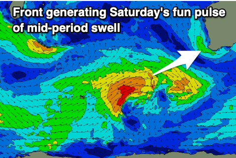
Our new mid-period SW swell for Saturday is on track, peaking into the afternoon and generated by a weak but favourably placed front that's currently north-east of the Heard Island region. A slow moving fetch of strong W/SW winds should generate some fun size across all locations, coming in at 4-5ft+ in the South West, and 2ft on the sets across Perth and Mandurah.

Winds are a little dicey for Saturday with a S/SE-SE offshore due to swing S/SW and become strong through the afternoon, while Sunday will see strong S/SE winds persisting all day as the swell eases.
Looking at next week, and the high moving in later week and through the weekend will be kept at arms distance thanks to a deepening inland heat trough. This will bring persistent, strong S/SE-SE winds through next week, with smaller swells owing to the blocking effects of the high. All in all Perth and Mandurah look tiny with small surf pulsing between 3-4ft on the magnets. More on this Friday.

