Good surf over the coming days
Western Australia Surf Forecast by Craig Brokensha (issued Monday November 28th)
Best Days: Tomorrow morning in the South West and Mandurah, all locations Wednesday morning, Saturday morning keen surfers all locations
Features of the Forecast (tl;dr)
- Moderate-large S/SW groundswell building tomorrow, peaking in the PM with moderate-fresh E/SE-E tending strong S/SW winds
- Easing S/SW swell Wed with moderate-fresh E/SE-SE tending S/SW winds in the South West, gusty NE tending NW in the north
- New S/SW groundswell for later Wed, easing Thu with moderate W/SW-SW winds
- Smaller Fri with S/SE tending S/SW winds
- Small mid-period SW swell Sat with strengthening S/SE winds, easing Sun with strong SE tending S/SE winds
Recap
Average surf Saturday across the South West with a slight improvement in conditions, cleaner Sunday with a small lift in swell. Perth and Mandurah were clean in the mornings but with tiny surf.
Today the small bump of swell has dropped back to 3ft in the South West with great conditions, tiny to the north.
This week and weekend (Nov 29 – Dec 4)
We've got a good couple of days ahead for the South West as S/SW groundswells move in under favourable winds both tomorrow and Wednesday ahead of a trough and onshore breezes Thursday.
Firstly, looking at the swells, and tomorrow's (which will peak into the afternoon) was generated by a healthy polar low swinging in along the polar shelf since late last week.
 Pre-frontal W/NW gales west of the Heard Island region weakened and broadened while moving east and we should see the swell reaching 6ft across the South West tomorrow afternoon with 2ft sets in Mandurah, 1-2ft across Clifton.
The swell will start to ease Wednesday, down a little on tomorrow afternoon's size. Winds will be best through the mornings and E/SE-E tomorrow morning ahead of strong S/SW sea breezes, E/SE-SE Wednesday morning in the South West, NE to the north with S/SW sea breezes in the South West and NW sea breezes across Perth and Mandurah.
This difference in winds will be linked to a low forming off our coast, pushing east on Thursday bringing W/SW-SW winds to all locations.
Unfortunately this will spoil another pulse of S/SW groundswell that should be seen Wednesday afternoon, easing into Thursday.
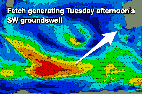
 The source of this swell will be a strong but late forming low in our swell window today, producing a fetch of gale to severe-gale W/SW winds with storm-force core wind speeds.
The late formation and acute direction won't be ideal but we should still see 6ft sets in the South West, small and to 2ft max across Mandurah and 1-2ft in Perth. Unfortunately the weak low will bring those onshore winds Thursday, with Friday being smaller and with a slight improvement in conditions under a lighter S/SE morning breeze.
Into the weekend, we'll see strengthening S/SE winds as a high pressure system starts moving in from the west, with stronger SE breezes due into Sunday morning.
 Swell wise, a small mid-period SW swell is due on Saturday, generated by a relatively weak but more favourably aligned front projecting strong W/SW winds towards us.
This should boost the South West back to 4-5ft with 1-2ft sets in Perth and Mandurah. The swell will ease into Sunday under those stronger SE winds.
Longer term there's nothing too major due into next week and winds look to be generally SE in the mornings before going more east later in the week. We'll have a closer look at this on Wednesday.

