Average weekend, better next week
Western Australia Surf Forecast by Craig Brokensha (issued Friday November 25th)
Best Days: Keen surfers Sunday and Monday mornings in the South West, Tuesday morning in the South West, Wednesday morning all locations
Features of the Forecast (tl;dr)
- Small, weak mid-period SW swell for this afternoon, easing tomorrow with moderate S/SE tending strong S/SW-SW winds
- Small S/SW swell Sun with mod-fresh SE tending S/SW winds
- Easing surf Mon with similar winds (likely more E/SE at times in the AM)
- Mod-large S/SW groundswell building Tue with mod-fresh E/SE winds ahead of sea breezes
- Easing S/SW swell Wed with mod-fresh E/SE winds ahead of sea breezes
- Reinforcing smaller S/SW swell Thu with S/SW winds
Recap
Tiny surf yesterday with light to moderate onshore winds, similar today in Perth and Mandurah but a small lift in swell has been in the South West with variable winds and heavy downpours. Winds are due to swing W/NW and then S/SW through the day.
This weekend and next week (Nov 26 – Dec 2)
A surface trough linked to the wet weather and funky winds today will move through overnight, bringing a S/SE change and moderate S/SE winds to all locations tomorrow morning ahead of S/SW-SW sea breezes.
Swell wise a small mid-period SW swell should be in the water but only to 3ft+ or so on the magnets in the South West, tiny across Perth and Mandurah.
Come Sunday, a new pulse of better mid-period S/SW swell should be seen across the South West magnets, generated by a fetch of sub-gale-force W/NW winds moving off axis through our swell window the last couple of days.
It'll be inconsistent and mostly around 4ft but expect the rare bigger one at times through the day with a moderate to fresh SE breeze. Perth and Mandurah will be tiny.
Similar if not slightly more offshore winds are due Monday morning but with easing, smaller 3-4ft waves on the South West magnets.
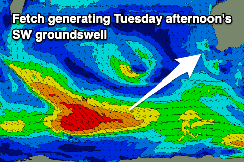
 Now, our better pulses of S/SW groundswell for next week are on track, with the first being generated by a polar front that's formed just west of the Heard Island region. A good fetch of W/NW gales will weaken while pushing east but remain just below gale-force while projecting east.
The progression will follow a similar track to the one generating Monday's swell but with its earlier and stronger initial stages, we should see it generating a moderate-large S/SW groundswell for Tuesday, building to a good 6ft in the South West, 2ft in Mandurah and 1-2ft across Perth into the afternoon.
Easing surf from a slightly smaller if not similar size is due Wednesday ahead of a reinforcing of more southerly angled, S/SW swell Thursday.
This secondary pulse will be generated by a late forming low to our south-west on the backside of the frontal progression and only slow the easing trend, with dropping 4-5ft waves in the South West Thursday morning, tiny to the north.
Local winds on Tuesday morning as the swell builds look great and moderate to fresh out of the E/SE, easing ahead of sea breezes, similar Wednesday. Thursday looks dicey as a trough brings a SW change to all locations but we'll have a closer look at this Monday.
Longer term, small levels of background SW swell are due, but we'll have another run over the charts Monday. Have a great weekend!

