Slow period as storm track remains focussed across the south-east
Western Australia Surf Forecast by Craig Brokensha (issued Monday November 21st)
Best Days: South West swell magnets today, tomorrow morning and Sunday morning
Features of the Forecast (tl;dr)
- Easing S/SW swell over the coming days with a moderate E/SE-SE offshore in the AM
- Smaller Wed with E/SE tending SW winds, NE tending NW in Perth and Mandurah
- SW-W/SW winds on Thu, SW tending S/SW Fri
- Fun new mid-period S/SW swell Sun with E/SE tending S/SW winds, smaller Mon with E tending SW winds
Recap
Solid, onshore surf across the South West on Saturday, improving yesterday as winds tended more SE, best in semi-protected spots. Perth and Mandurah offered better but lumpy 2-3ft waves on Saturday, smaller and less consistent Sunday but cleaner with fun 2ft sets on the magnets.
This morning the South West is cleaner along with a further drop in size, but the magnets are still 4-5ft. The swell is out of the S/SW with Mandurah and Perth coming in at a tiny 1-1.5ft.

Good sets and great conditions this morning
This week and next (Nov 22 - 27)
The week ahead isn't too great surf wise, as we see a drop in swell tomorrow (but with offshore winds), ahead of deteriorating winds and conditions from Wednesday as a surface lows forms offshore and then moves inland.
Tomorrow morning on the magnets in the South West will be the pick with a moderate E/SE-SE offshore due along with easing 3-4ft sets, tiny across Perth and Mandurah.
Wednesday will become smaller and early light E/SE winds will shift SW across the South West, NE tending NW to the north ahead of W/SW-SW winds across all locations on Thursday.
Thursday will see a low point in swell ahead of some small mid-period energy into the afternoon, easing Friday. The source is a weak low that's currently north-east of the Heard Island and will generate a pre-frontal fetch of strong W/NW winds before weakening tomorrow.
 A small lift in size to 4ft is due on Thursday afternoon in the South West, tiny elsewhere, easing from a similar size Friday.
Those onshore winds will creating poor conditions Thursday, while Friday will also be poor with moderate to fresh SW tending S/SW breezes.
A high looks to move in on the weekend, bringing a S/SE breeze Saturday morning and cleaner conditions Sunday morning as winds shift more E/SE.
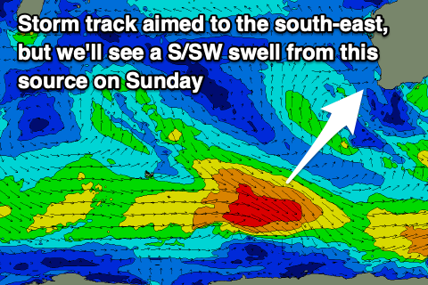
Swell wise, Saturday will be smaller but a fun new S/SW swell is expected on Sunday, generated by a strengthening polar low late in our swell window. A fetch of strong to gale-force W/NW winds should hopefully produce 4-5ft sets in the South West with that better wind.
The swell will ease into early next week and there still isn't too much on the cards to follow up thanks to the Long Wave Trough being focussed up and across the south-east of the country. This is resulting in storms being deflected south-east away from us, then back up towards Victoria. More on this in the coming updates though.

