Windy weekend, best Monday
Western Australian Surf Forecast by Craig Brokensha (issued Friday November 18th)
Best Days: Perth and Mandurah Saturday and Sunday mornings, protected spots in the South West Sunday morning, Monday morning
Features of the Forecast (tl;dr)
- Mod-large mid-period S/SW swell today, continuing tomorrow with strong SW winds in the South West, easing later and tending S/SW (variable tending N/NE winds in Perth and Mandurah in the AM)
- Mod-large S/SW groundswell Sun AM with moderate S/SE winds tending strong SW (SE early Perth and Mandurah)
- Easing size Mon, with some weaker reinforcing S/SW swell slowing the trend. E/SE tending SW winds
- Smaller Tue with early SE tending SW winds
Recap
Poor conditions with strengthening onshore winds and no size at all yesterday morning, a bit bigger today but still very low in quality.
This weekend and next week (Nov 19 - 25)
The strong cold outbreak linked to our current episode of poor weather and strong onshore winds will move across us today, try and clear tomorrow but be stopped by a weak trailing front clipping us.
This will prevent conditions improving across the South West until Sunday morning but more so Monday.
 Swell wise, the front pushing up and into us today will generate moderate to large levels of mid-period S/SW swell, 6ft+ in the South West as we’re already seeing and 2-3ft to the north.
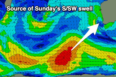
Similar sized waves are due tomorrow morning ahead of our stronger groundswell into the late afternoon but more so Sunday morning. This swell, as discussed through the week has been generated by a healthy polar low firing up in the Heard Island region, generating a good fetch of SW gales.
Stronger 6-8ft sets are due in the South West Sunday morning from this source, 2-3ft Mandurah and 2ft to occasionally 3ft in Perth.
Coming back to the local winds and fresh to strong SW winds will persist in the South West tomorrow morning, easing a touch into the afternoon while tending S/SW. Perth and Mandurah should see more variable winds, likely tending N/NE before reverting to the SW.
 Come Sunday a high will start to move in from the west, bringing moderate S/SE winds to the South West, best in protected spots. Lighter SE winds are due in Perth and Mandurah ahead of strong SW sea breezes into the afternoon.
Monday is still the pick of the coming period with an offshore E/SE breeze and easing 4-6ft sets across the South West magnets (4-5ft with the rare bigger one), 2ft in Mandurah and 1-2ft across Perth. The front clipping us today will have a trailing fetch of W/SW winds at its base, generating some reinforcing mid-period S/SW swell for Monday, slowing the easing trend.
From Tuesday winds will start to deteriorate again, (early E/SE-SE) as a deepening inland trough/low drifts south, squeezing the high to our south. This will bring S’ly winds from Tuesday afternoon, shifting more S/SW into the afternoon Wednesday and then SW come Thursday.
Size wise, some small sized mid-period SW swell is due Thursday/Friday, with a touch more energy likely next weekend as winds go back to the S/SE-SE. All in all there’s nothing too major at all due longer term as spring finally bites. More on this Monday. Have a great weekend!

