Poor couple of days, improving slowly through the weekend
Western Australia Surf Forecast by Craig Brokensha (issued Wednesday November 16th)
Best Days: Perth and Mandurah Saturday morning and Sunday morning, protected spots in the South West Sunday morning, Monday morning, protected spots in the South West Tuesday morning
Features of the Forecast (tl;dr)
- Building windswell with strong SW winds tomorrow
- Further increase in mid-period energy Fri with strong S/SW-SW winds, holding Sat with strong S/SW-SW winds in the South West (SE-E/SE further north in the AM)
- Mod-large mid-period S/SW swell for Sun with S-S/SE winds in the South West, SE further north
- Easing mod sized S/SW swell Mon with E/SE tending S/SW winds
- Smaller Tue with strengthening SE tending S/SE winds
- Smaller Wed with strong S/SE winds
Recap
Clean, easing surf through yesterday, best in the South West, while the swell and surf has bottomed out into this morning. Morning offshore winds are now shifting onshore across the South West and will follow further north as a trough deepens to our west.

Fun sets yesterday AM
This week and next (Nov 17 - 25)
Looking at the end of the week and the trough deepening through today will strengthen while moving across us tomorrow in the form of a weak low.
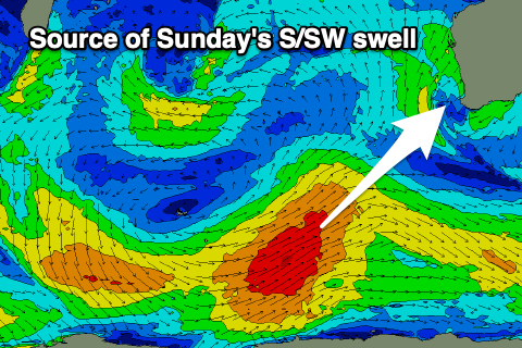
This will bring strong SW winds and a building windswell though with no real quality. This low will draw up a stronger polar frontal system with it currently positioned east of the Heard Island region, generating a fetch of SW gales.
As the front approaches us it'll weaken, but still bring strong S/SW-SW winds to all locations on Friday with a further increase in windswell and mid-period energy.
Building surf to 6ft+ is due in the South West, 2-3ft in Perth and Mandurah with stormy conditions.
As we move into the weekend a high will start to slowly move in from the west, not before one final front projects a fetch of strong S/SW winds through our southern swell window. This will keep winds blowing from the S/SW-SW across the South West on Saturday, though Perth and Mandurah should see a morning E/SE-SE offshore.
 Swell wise, a moderate to large S/SW swell is due off the polar fetch today, arriving overnight Saturday and peaking Sunday morning. So ahead of this, we'll continue to see weaker levels of localised swell to the 6ft+ range in the South West and 2-3ft further north in Perth and Mandurah.
The stronger mid-period energy for Sunday should come in at 6ft to occasionally 8ft across the South West magnets with 2-3ft waves in Mandurah and 2ft surf across Perth. Winds will remain out of the S'th generally on Sunday in the South West, possibly tending S/SE at times but we'll review this Friday.
Perth and Mandurah look cleanest with morning SE winds ahead of sea breezes.
 Come Monday, the high will fully move in, swinging winds E/SE, along with fun sized sets easing from 4-6ft in the South West, 2ft across Mandurah and Perth.
It looks like winds will start to deteriorate as the week progresses as an inland trough and low deepen, squeezing the high and shifting winds back to the S/SE-SE on Tuesday while strengthening, strong S/SE-S on Wednesday.
Swell wise, the weekend's S/SW energy will continue to ease with no new size due until later in the week and next weekend. Winds look dicey for this so make the most of the windows of cleaner conditions with swell over the coming period.

