Good swell with onshore winds tomorrow
Western Australia Surf Forecast by Craig Brokensha (issued Wednesday November 9th)
Best Days: Keen surfers at dawn in Perth and Mandurah tomorrow morning, protected spots late in the South West, protected spots Friday morning, Saturday - Sunday - Monday mornings in the South West
Features of the Forecast (tl;dr)
- Mod-large SW groundswell for later today but more so tomorrow, peaking in the PM
- Increasing W/NW winds ahead of a strong S tending S/SE change tomorrow PM (possible variable at dawn Perth and Mandurah)
- Easing swell Fri with strong S/SE winds, fresher S/SE-SE Sat
- New small sized, mid-period S/SW swell for Sat PM, easing Sun with SE tending SW winds
- Slightly better mid-period S/SW swell for Mon PM with E tending strong SW winds, easing Tue with early E/SE tending S/SW winds
Recap
Solid surf in the South West yesterday morning with improving conditions and 5-6ft sets on the magnets, average into the afternoon with sea breezes. Mandurah was 2ft and Perth 1ft to occasionally 2ft.
Today the swell eased back a touch in the South West with early clean conditions which have since deteriorated with a S/SW change. Mandurah was again 2ft with slow 1-2ft sets in Perth.

Decent conditions early this AM ahead of the change
This week and next (Nov 10 - 18)
Into the late afternoon today, a moderate to large SW groundswell is due to arrive, peaking through tomorrow across our coasts, generated by a strong polar low moving through our swell window on the weekend.
Winds locally will be average across most locations as today's trough and S/SW change is followed by a weak low moving in tomorrow, bringing freshening W/NW winds to the South West. We may see variable winds early across Perth and Mandurah before winds go onshore.
A S'ly change is due across the South West into the mid-afternoon with winds possibly reverting to the S/SE late.
Size wise, the SW groundswell should provide 6-8ft sets in the South West, with improving options across protected spots into the late afternoon/evening, 2ft+ in Mandurah and 2ft across Perth.
The low will produce a close-range, mid-period S'ly swell for Friday but to no major size and the models are combining this energy with the existing, easing groundswell, over-forecasting the size across most spots.
 Instead expect a drop in size from tomorrow, easing back from 5-6ft in the South West on Friday morning, 1-2ft in Mandurah and 1-1.5ft across Perth. Winds will be strong but out of the S/SE, limiting surfing options to protected spots.
Saturday looks a little better as winds ease and become fresh, tending more S/SE-SE during the morning along with a reinforcing mid-period S/SW swell due to arrive through the day.
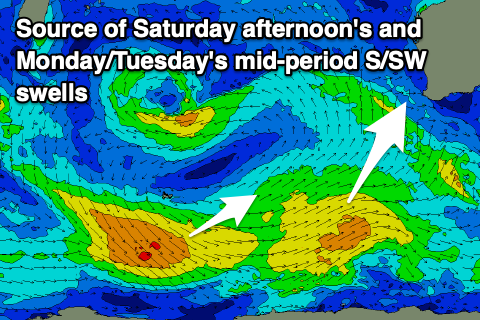
The polar front linked to this swell is currently generating a weak fetch of W/SW winds to the east of the Heard Island region. No major size is due but it should maintain 4ft+ waves in the South West through the day, easing from 4ft on Sunday morning (tiny further north).
Winds will improve further Sunday, swinging more SE, even E/SE across select locations, ahead of sea breezes.
Moving into early next week, we've got a secondary pulse of mid-period S/SW swell, generated by a slightly stronger polar front moving in behind the current one. Winds won't real gale-force but we should still see 4-5ft sets develop in the South West through the day, easing from 4ft+ on Tuesday, while Mandurah doesn't look to top 1-1.5ft, tiny to the north again.
Cleaner conditions are expected on Monday as a high shifts in under us, bringing E'ly offshores that should hold until early afternoon ahead of sea breezes. Tuesday should see an early E/SE offshore before a trough moves in mid-late morning, bringing a strong S/SW change.
Winds are a little unsure through the middle to end of the week, but a high is likely to move in behind the trough, along with some new moderate-large sized S/SW groundswell. We'll take a closer look at this Friday though as the models diverge slightly.

