Deteriorating conditions this week
Western Australia Surf Forecast by Craig Brokensha (issued Monday November 7th)
Best Days: Margs and Mandurah tomorrow morning, protected spots for the keen Friday and Saturday mornings, Sunday morning and Monday morning in the South West
Features of the Forecast (tl;dr)
- Easing SW swell tomorrow with moderate SE tending E/SE winds ahead of strong S-S/SW sea breezes
- Early S/SE winds Wed, tending SW during the AM and freshening
- Mod-large SW groundswell for later Wed but more so Thu, peaking in the PM
- Increasing W/NW winds ahead of a strong S/SW change
- Easing swell Fri with strong S/SE winds, fresher Sat
- New moderate sized, mid-period S/SW swell for later Sun, peaking Mon AM with SE tending S/SW winds Mon, E tending W/SW Mon
Recap
Generally small surf across all locations on the weekend, with Saturday offering the most size but cross-shore winds in the South West, cleaner and 1-2ft to the north. Yesterday was a touch smaller but cleaner with fun waves on the South West magnets.
Today a reinforcing swell has boosted wave heights a touch with improving conditions across selected spots in the South West with sets to 4-5ft, 1-2ft in Mandurah with 1-1.5ft waves across Perth. We should see the swell reaching 5-6ft in the South West, 2ft in Mandurah and 1-2ft across Perth but with afternoon sea breezes.
This week and weekend (Nov 8 - 13)
Tomorrow is worth making the most of across the South West as winds will deteriorate from Wednesday and remain average until next week.
Today's mid-period SW swell should peak this afternoon and ease back through tomorrow with a moderate SE tending E/SE breeze ahead of afternoon sea breezes. Easing 4-5ft+ sets are due across the South West, 2ft in Mandurah and 1ft to nearly 2ft in Perth, best in the morning.
Come Wednesday a trough will bring deteriorating conditions with an early S/SE breeze due to swing SW during the morning and increase through the afternoon.
The trough is forecast to form into a low, meandering slowly east through the end of the week. This will bring increasing W/NW winds on Thursday ahead of a strong S/SW afternoon change, swinging S/SE on Friday and being strong across all locations.
Winds should abate a little but persist from the S/SE on Saturday morning, giving into stronger afternoon S/SE-S sea breezes. Sunday morning may see better SE winds develop in the South West but Monday looks the pick with E'ly offshore winds.
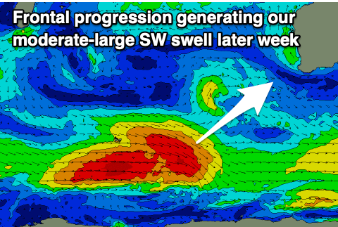
Coming back to the swell and a strong polar low that formed south-west of us on the weekend has generated a fetch of gale-force W/NW tending W/SW winds and a moderate-large sized SW groundswell for later Wednesday but more so Thursday.
Building surf to a peak on Thursday in the 6-8ft range is due in the South West, 2ft+ across Mandurah and 2ft in Perth on the sets but with those poor winds.
Friday should offer a couple of options out of the wind but the swell will be on the ease, mixed in with a weak, local S windswell. Easing sets from the 6ft range are due in the South West, 2ft in Mandurah and 1-2ft max across Perth.
Smaller surf will be seen into the weekend as those winds slowly improve.
 Into Sunday afternoon and Monday morning, a new moderate sized mid-period S/SW swell is due, generated by a strengthening polar low to our south-southwest late this week.
A fetch of strong to near gale-force W/NW winds should produce a kick in size to 3-5ft across the South West later Sunday, but Monday morning looks the pick of it with the offshore breeze. Perth and Mandurah aren't expected to see any size from this source.
A couple of secondary S/SW swells are likely through next week with winds out of the south-eastern quadrant, but we'll have another look at this Wednesday.

