Average period in general with a few windows
Western Australia Surf Forecast by Craig Brokensha (issued Friday October 14th)
Best Days: Tomorrow morning in the South West, Tuesday morning all locations, Wednesday morning in the South West
Features of the Forecast (tl;dr)
- Easing surf tomorrow with light E/SE-SE tending S/SW winds
- Small weak SW swell for Sun with light S/SW-SW tending stronger W winds
- Small-moderate sized, mid-period SW swell building Mon with strong S/SW winds (S/SE early Perth)
- Easing SW swell Tue with variable winds ahead of sea breezes
- Smaller Wed with E/SE tending SW winds
- Moderate-large, mid-period SW swell building Fri, peaking Sat with S/SW winds
Recap
Funky winds across the South West yesterday, varying between offshore and onshore through the central region of the cape, more reliable to the north with a drop in swell back to 3ft.
Perth and Mandurah were still 1-2ft, clean and fun.
Today the swell is tiny across Perth and Mandurah, but a small pulse of SW groundswell has boosted wave heights to either side of 4ft in the South West with dicey S winds. Protected spots are OK for the keen.

Slight kick in energy today, with a 5ft 'bomb' set rolling through
This weekend and next week (Oct 15 - 21)
Moving into the weekend, conditions will become much cleaner across all locations in the South West with an E/SE-SE offshore wind from cape to cape, but today's small pulse of SW groundswell is due to ease back from a small 3-4ft. Perth and Mandurah will be clean but remain tiny.
A small, weak reinforcing SW swell may maintain 3ft to possibly 4ft waves on Sunday across the South West, but the source is a weak front moving through tomorrow, and the local winds look to deteriorate with a trough. This will bring weak S/SW tending SW winds, strengthening from the W through the afternoon. Perth and Mandurah are also due to see these poor winds but tiny surf in any case.
The change in winds will be thanks to another weak low projecting up towards us Sunday, weakening on approach, with lingering, strong S/SW winds across most locations Monday. Perth should see S/SE winds, and swell wise, the energy from this low only looks to come in at 4-5ft+ in the South West, 2ft Mandurah and 1-2ft Perth, though peaking in the afternoon when winds are back onshore.
 The swell will ease into Tuesday as winds become variable in the South West, even light offshore, with sets dropping from the 4ft range in the South West, tiny and clean further north to 1-1.5ft.
Small pulses of mid-period SW swell energy are expected on Wednesday to 4ft in the South West with offshore winds, generated by a pre-frontal fetch of strong W/NW winds.
The models are showing a kick in size Wednesday afternoon and Thursday but the source is a very long-range SW groundswell and it isn't expected to offer any real additional size. The models are incorrectly combining swells and expected surf to 3-5ft max in the South West but with a SW change on Thursday.
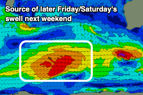
A better mid-period SW swell is due to build Friday and peak Saturday morning, generated by a broad but weak fetch of polar W/SW winds early-mid next week. Size wise, fun surf in the 6ft range is due across Margs, 2ft in Mandurah and 1-2ft across Perth next Saturday morning but with unfavourably S/SW winds. Sunday morning looks a bit cleaner as winds shift more SE but we'll have a closer look at this Monday. Have a great weekend!

