Generally average weekend, more options next week
Western Australia Surf Forecast by Craig Brokensha (issued Friday October 7th)
Best Days: Today, early tomorrow, Perth and Mandurah Tuesday morning, Thursday morning south magnets, Friday morning
Features of the Forecast (tl;dr)
- Easing SW swell over the weekend with early E/NE tending N/NE then N/NW winds tomorrow
- Fresh W-W/SW winds Sun (variable further north in the AM)
- Building mid-period SW swell Mon with strong SW winds
- Easing SW swell with gusty S/SW winds Tue (S/SE-SE Mandurah, E Perth)
- Smaller Wed with S/SW winds in the South West, S/SE-SE further north
- Small S swell Thu with E tending NW winds
- New SW groundswell Fri with E/NE tending NW winds
Recap
Perth was the only decent option yesterday morning with light offshore winds and lumpy 2ft sets through the morning, down on Wednesday afternoon and evening. Mandurah saw winds remaining dicey, poor in the South West.
Today, all locations are looking great with yesterday's best pulse of mid-period SW energy easing back from 6-8ft in the South West with lump/clean conditions, 2-3ft in Mandurah and 2ft across Perth.

Cleaner surf this AM
This weekend and next week (Oct 8 - 14)
We'll see the current swell continuing to ease into the weekend and there's a small window of opportunity tomorrow morning with a dawn E/NE offshore in the South West due to swing more N/NE during the morning and then N/NW into the afternoon while freshening.
Perth and Mandurah should see E/SE tending E/NE winds ahead of sea breezes. Size wise Margs looks to be easing from the 4ft+ range, 1-2ft in Mandurah and 1-1.5ft across Perth.
Sunday and Monday look to be lay days with a low point in swell on the former and with fresh W-W/SW winds. Perth and less so Mandurah are due to see variable winds early but there'll be no decent size.
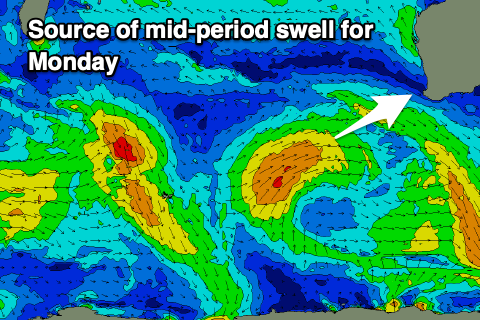
 Strong SW winds will be seen on Monday as a weak polar low that's currently south-west of us slowly projects north-east towards us on the weekend while weakening.
This low will generate a mid-period SW swell for Monday, peaking into the afternoon to 6ft+ in the South West, 2-3ft in Mandurah and 2ft across Perth.
Unfortunately while the low will weaken, it's forecast to linger off our south through early next week, keeping onshore winds blowing in the South West out of the S/SW on Tuesday and Wednesday.
Perth and Mandurah should see periods of morning S/SE-SE winds both days (E'ly Tuesday morning Perth) but with easing sets from 2ft+ Tuesday morning in Mandurah, 2ft across Perth.
 The low will generate mid-period levels of S/SW swell for Margs Wednesday, Thursday but only on the regional south magnets.
We'll hopefully see the low push east Thursday resulting in light E winds and with that S/SW swell, sets to 3-4ft are due on the south magnets, tiny Perth and Mandurah.
Longer term we may see a small to moderate sized SW groundswell late week generated by a strong polar low firing up north of the Heard Island region and dropping south-east through our swell window early next week. 4-6ft sets are due at this stage with morning offshore winds. We'll have a closer look at this on Monday.
Beyond this, small to moderate pulses of mid-period swell are on the cards with favourable winds. More on this Monday though. Have a great weekend!

