Smaller swells with generally favourable winds
Western Australia Surf Forecast by Craig Brokensha (issued Wednesday September 28th)
Best Days: Today ahead of the sea breeze, tomorrow morning Margs and Mandurah, Friday morning on the magnets in the South West, Monday morning all locations, Tuesday morning Margs and Mandurah
Features of the Forecast (tl;dr)
- Easing surf Thu with gusty SE tending stronger S/SE winds
- Small Fri AM ahead of a new SW groundswell building later, peaking Sat AM. E/NE winds ahead of sea breezes
- Strengthening S/SE winds
- Moderate sized W/SW swell building later Sun, peaking Mon AM with E/SE tending S/SW winds Sun, easing Tue with similar E/SE tending SW winds
- Large stormy swell building Thu with strong S/SW winds
Recap
A continuation of good surf across all locations yesterday with Monday afternoon's reinforcing SW groundswell easing back from 6ft+ in the South West, 2-3ft in Mandurah and 2ft across Perth. Sea breezes kicked in late morning, creating average surf into the afternoon.
Today the swell is a touch smaller but steadying with the arrival of a mid-period SW swell (shown below). Sets are still a good 6ft in the South West, 2ft across Mandurah but back to 1-1.5ft in Perth. Winds look to strengthen from the S/SE in the South West this afternoon, shifting S/SW further north so make the most of this morning.

Spot the surfer on the right. Easy 2x overhead this morning
This week and next (Sep 29 – Oct 7)
Easing surf is due over the coming days, with today's mid-period SW swell due to ease through tomorrow and drop further into Friday morning as winds slowly improve for more exposed breaks.
A fresh SE'ly is due tomorrow morning, shifting S/SE into the afternoon and strengthening, with E/NE winds on Friday ahead of gusty sea breezes. Easing sets from 4-5ft are due in the South West tomorrow morning, 1-2ft max in Mandurah and 1ft+ across Perth. Friday will be smaller again.
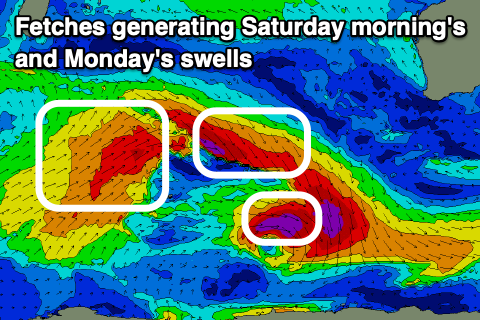
 Into Friday afternoon a new pulse of SW groundswell is expected to arrive, peaking Saturday morning, generated by an off-axis fetch of severe-gale W/NW winds tracking south-east through our swell window today.
We should see a little boost in size back to 4-5ft across Margs, tiny in Mandurah with 1-1.5ft sets, smaller in Perth.
Winds unfortunately look to tip back to the S/SE Saturday, strengthening through the day and with the smallish swell, options will be limited.
Winds should swing more E/SE-SE through the morning on Sunday as the swell eases, windy into the afternoon.
A fun pulse of mid-period W/SW swell from the backside of the progression generating the fetch of severe-gale NW winds should fill in overnight Sunday, peaking Monday. A couple of back to back fetches of W/SW gales should produce 5-6ft sets across the South West, 2ft in Mandurah and Perth along with offshore E/SE winds ahead of sea breezes.
 Similar conditions should be seen Tuesday but with smaller, easing surf.
Another mid-period swell is due into Tuesday afternoon, peaking Wednesday but below Monday morning's size. This looks to be generated by a weak polar low on the weekend, with a fetch of strong W/NW winds due to generate a small pulse of swell to 4ft on the sets in the South West.
Longer term it looks like a polar front will project north-east while strengthening and deepening into a mid-latitude low directly south-west of us. This will bring strong onshore winds and a large, stormy S/SW swell with possibly follow up mid-latitude frontal activity into the following week. We'll have a closer look at this on Friday.

