Slow moving low spoils conditions
Western Australia Surf Forecast by Craig Brokensha (issued Wednesday September 14th)
Best Days: Protected spots around Mandurah tomorrow morning, Friday morning Perth and Mandurah, Sunday morning
Features of the Forecast (tl;dr)
- Large reinforcing S/SW groundswell tomorrow, easing Fri
- Strong S/SW winds tomorrow (likely tending S/SE for a period in the AM in Mandurah, less likely Perth)
- E/SE winds Fri AM Mandurah and Perth, mod-fresh S/SW in Margs
- Smaller surf Sat with increasing W/NW tending SW winds across the South West, cleaner in the morning to the north
- Small-moderate sized, inconsistent SW groundswell Sun with SE tending SW winds
Recap
Sizey swell building across the metro locations yesterday but with poor, stormy conditions, holding large across all locations today with a continuation of onshore winds.
This week and next (Sep 15 - 23)
The southern extent of the state is under the influence of a strong, slow moving mid-latitude low and with the low only edging slightly east over the coming days, winds will remain onshore for the most part through tomorrow out of the S/SW and strong. Check out Satview for a great overview of the storm and embedded fronts.
Unfortunately it looks like the chance for cleaner conditions in Perth and Mandurah is now 50/50. Mandurah should see winds tip S/SE through the morning but Perth looks a little dicey, with Friday being cleaner under light E/SE winds (still moderate to fresh S/SW in the South West).
The average winds are thanks to the low being slower moving than initially forecast on Monday but this will also keep the size up out of the S/SW a little longer across the South West.
Looking at tomorrow and Perth and Mandurah should ease back from 2-3ft and 3ft respectively with 6-8ft sets across Margs.
Come Friday we'll see the South West still offering 6ft sets but on the ease with 2ft waves across Mandurah and 1-2ft leftovers in Perth. Those winds will be best for the metro locations though ahead of sea beezes.
 Moving into the weekend and Saturday looks smaller again but with dicey winds as another approaching front brings increasing W/NW tending strong W/SW winds in the South West (possibly variable early).
Sunday still looks clean with a SE offshore in the morning and new pulse of small to moderate sized SW groundswell.
The source of this will be a strong but poorly constructed polar low forming north-east of the Heard Island region tomorrow. A pre-frontal fetch of gale to severe-gale NW winds will be followed by a brief intensification of storm-force W/SW-SW winds, weakening quickly while tracking south-east tomorrow evening.
 This swell will be flukey but sets to 4-6ft are due in the South West, a slow 2ft on the sets in Mandurah and 1-1.5ft across Perth but with those favourable morning winds.
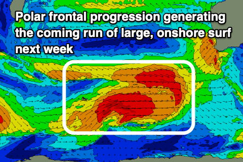
Of greater importance is a slow moving polar frontal progression that's due to fire up south-west of us from the weekend, persisting most of next week owing to a slow moving node of the Long Wave Trough.
We're set to see a prolonged, large SW groundswell event running from Tuesday through Friday next week but with poor, persistent NW to SW winds. Perth and Mandurah may see periods of more variable winds but we'll have to nut this out in the coming forecasts.

