Tricky but more favourable winds early tomorrow
Western Australia Surf Forecast by Craig Brokensha (issued Monday September 5th)
Best Days: Tomorrow morning all locations, Perth and Mandurah Wednesday morning, Thursday all locations, Friday Margs and Mandurah, Saturday in the South West, early Sunday in the South West
Features of the Forecast (tl;dr)
- Building W/SW groundswell later today, peaking tomorrow with morning E winds in the South West (E/NE-NE Perth/Mandurah), swinging SW later morning and freshening
- Additional W/SW swell for the metro locations during the day
- Easing mix of swells Wed with S/SW winds in the South West, E/NE in the AM across Perth and Mandurah
- Reinforcing moderate sized + SW swell Thu AM with E'ly tending NW winds
- Easing swell Fri with E tending S/SW winds
- Building mid-period S/SW swell later Sat, easing Sun
- Fresh E tending variable winds Sat, fresh NE tending NW winds Sun
Recap
Small, clean but fading 3ft sets on the South West magnets Saturday, 1-2ft on Sunday. Further north it was tiny and only for beginners.
This morning winds have gone onshore and we've reached a low point in swell.
This week and weekend (Sep 6 - 11)
 Later today we've got a new pulse of W/SW groundswell due, with it expected to peak through tomorrow across the state.
This swell was generated late last week by a strong mid-latitude storm, pushing east while generating a fetch of gale to severe-gale W/SW winds, and even some storm-force core winds were picked up by satellite.
The swell is due to come in at 6-8ft in the South West tomorrow with 2-3ft sets across Perth and Mandurah.
Winds are tricky as a low sitting west of us projects north-east and then east, bringing a window of offshore E'ly winds across the South West, E/NE-NE in Perth and Mandurah, shifting onshore later morning as the low moves east. The low itself will generate some additional swell into the afternoon across Perth and Mandurah more to 3ft.
 Wednesday is a tricky one but onshore S/SW winds look to persist across the South West as the W/SW swell eases, while Perth and Mandurah should see morning E/NE winds and easing 2-3ft sets.
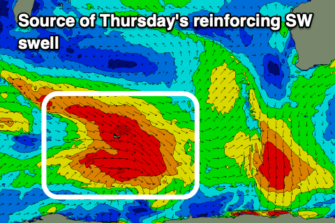
Come Thursday we're looking at clean conditions across all locations with an E'ly offshore wind and reinforcing mid-period SW swell.
The source of the reinforcing energy was a broad but brief polar low forming in the wake of the system linked to tomorrow's swell, with a fetch of gale-force W/NW winds directed towards the polar shelf.
Sets to 6ft should persist across the South West 2ft in Mandurah and 1ft to possibly 2ft in Perth with this clean morning conditions, with weak NW afternoon sea breezes. Friday will become smaller along with morning offshore winds, S/SW-SW into the afternoon.
Saturday morning will be smaller again but clean with fresh E'ly offshore winds, variable into the afternoon ahead of a new, mid-period S/SW swell.
 The source of this swell will be a weak polar low to the east of Heard Island mid-late week and we should see the South West build to 4-5ft later in the day, easing from a similar size Sunday with tiny 1-1.5ft waves in Mandurah. Conditions will be best early with a NE offshore, shifting NW through the day ahead of a significant frontal progression.
At this stage the frontal progression is forecast to bring large, stormy waves to us into next week, but more on this Wednesday.

