Cleaner end to the week
Western Australia Surf Forecast by Craig Brokensha (issued Wednesday August 10th)
Best Days: All locations today and tomorrow, Margs early Friday, Perth and Mandurah Sunday
Features of the Forecast (tl;dr)
- Easing mid-period S/SW swell tomorrow with E/NE tending light N winds
- Small, mid-period SW swell Fri AM with gusty E/NE tending NE then stronger N/NE winds
- Low point in swell Sat with strong N-N/NE winds, shifting W/NW into the PM
Recap
Large, choppy waves in the 10ft+ range across the South West yesterday while Mandurah saw lighter winds through the morning and raw but workable 4ft surf, 3ft+ in Perth and initially bumpy/choppy, improving into the afternoon as winds eased.
Today is the day across Perth and Mandurah though with cleaner conditions and peaky head-high surf. Margs was better in protected spots with a bit of S'th in the wind and easing sets from 6-8ft.

Chunky in Perth yesterday PM
This week and weekend (Aug 11 - 14)
The current swell will continue to ease in size and power while dropping in period and swinging S/SW in direction through tomorrow as winds swing true offshore across the South West.
An E/NE breeze is expected ahead of variable afternoon N winds but with easing 3-5ft sets on the magnets, 1-2ft in Mandurah and 1-1.5ft across Perth. While on the smaller side it's worth making the most of as we'll see winds deteriorating from Friday, strengthening from the E/NE and shifting N/NE through the day.
A reinforcing pulse of mid-period SW swell should maintain 3-4ft sets across the South West, tiny to the north, generated by a relatively weak polar front yesterday.
A low point in swell is due on Saturday and early, strong N-N/NE winds will shift W/NW into the afternoon as a weakening mid-latitude front pushes in from the west.
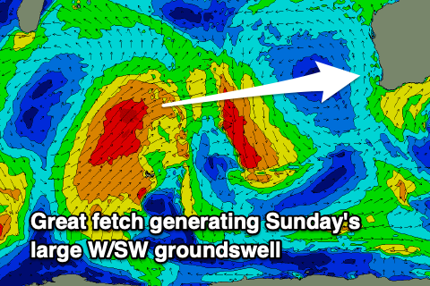
 The earlier stages of this front are producing a great fetch of W/SW gales through our western swell window today, breaking down tomorrow morning with one final burst into the evening, decaying on approach Saturday.
A large W/SW groundswell is due from this source on Sunday to 10ft in the South West, 3-4ft across Mandurah and 3ft in Perth.
Winds will ease quickly on Sunday as the front clears and continues to weaken, with morning NE winds due in Perth and Mandurah (light to moderate NW into the afternoon), average and freshening from the N/NW across the South West.
Strengthening N/NW winds are due on Monday ahead of the next front with a drop in size from Sunday, with Perth and Mandurah offering early N/NE breezes for the keen.
 This next front will be much weaker, generating a mid-period W'ly swell for later Monday and Tuesday but with gusty N tending W/SW winds on the latter when it peaks. Size wise it looks to peaky around 8ft in the South West Tuesday morning, 3ft+ in Mandurah and 3ft across Perth.
Additional pulses of larger W'ly swell are possible into the end of the week but the models diverge wildly regarding the formation of fronts around the broader low pressure gyre. EC has nothing of note and troughy weather with better winds. GFS larger, onshore and poor. More on this Friday.

