Easing surf with cleaner conditions
Western Australia Surf Forecast by Craig Brokensha (issued Friday July 15th)
Best Days: Tomorrow, Sunday morning selected spots, Monday morning for the keen
Features of the Forecast (tl;dr)
- Easing W'ly swell tomorrow with E/NE-NE winds (variable Perth and Mandurah into the PM, weak sea breezes Margs)
- Smaller Sun with freshening NE winds (E/NE tending NE in Perth and Mandurah)
- Small, weak W swell Mon (possible undersized at dawn) with E/SE tending S/SE winds (SE Perth and Mandurah)
- Inconsistent, long-period SW groundswell building Tue, peaking in the PM with NE tending N winds
- Building W swell Wed PM with strengthening N/NE tending N winds
- Easing S swell Thu with W winds, smaller Fri with W winds
Recap
Poor conditions across most locations yesterday with an approaching low and strengthening N tending NW winds. Perth was OK early with peaky 2ft sets for the keen.
Today everywhere is a mess with a fresh to strong onshore breeze and large W'ly swell.
This weekend and next week (Jul 16 - 22)
The weekend will provide much better surf across all locations but for the size, focus on tomorrow.
 The low linked to the current large swell and onshore winds is now weakening and moving east, and we'll see a strong high move in behind it, swinging winds offshore from the E/NE-NE across all locations, variable into the afternoon across Perth and Mandurah with weak sea breezes in the South West.
We'll see the swell from the low easing steadily in size, dropping from the 6ft range in the South West, 2-3ft in Mandurah and 2ft+ across Perth.
Sunday will become smaller but still just surfable across the metro locations, 3-5ft in the South West and with freshening NE winds in the South West, E/NE tending NE in Perth and Mandurah.
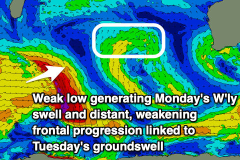
Winds should swing back to the E/SE across the South West on Monday and SE in Perth and Mandurah, along with a small pulse of weak W'ly swell. This has been generated by a weak mid-latitude front currently north of the Heard Island region and sets to 1-2ft should be see with Margs offering small 3ft+ sets.
Looking longer term, and out inconsistent SW groundswell (the same one that impacted J-Bay yesterday) is due to build through Tuesday and peak through the afternoon. With the source being so far away there'll be long waits for sets and no major size but the South West should build to 4-6ft with inconsistent 1-2ft sets in Mandurah and Perth.
A NE tending light N wind will offer OK conditions, deteriorating on Wednesday with strengthening N/NE tending N winds as a low deepens to our west again.
 This low doesn't look as favourable for swell production with a weak fetch of strong to gale-force W'ly winds produced temporarily through our swell window.
This looks to generate a moderate sized + W'ly swell for Wednesday afternoon and Thursday but with those poor winds, swinging W'ly on Thursday.
Another front approaching Friday may keep onshore winds blowing across the South West but we'll have a closer look at this on Monday.
Longer term, a series of stronger polar storms look to generate larger SW groundswells for next weekend and the following week but winds will remain an issue and onshore at this stage for Margs, cleaner to the north. More on this Monday. Have a great weekend!

