Poor end to the week, fun Saturday
Western Australia Surf Forecast by Craig Brokensha (issued Wednesday July 13th)
Best Days: Saturday, Sunday in the South West
Features of the Forecast (tl;dr)
- Inconsistent SW groundswell for tomorrow morning, easing
- Strong N/NW tending NW winds tomorrow (N/NE early Perth and Mandurah)
- Large W'ly groundswell for Fri AM, easing with strong but easing W/SW tending SW winds
- Easing W swell Sat with E/NE tending N/NE winds
- Smaller Sun with E/NE tending NE winds
Recap
Poor, deteriorating surf across the South West with a drop in swell from Monday, cleaner in Perth and Mandurah during the morning with 2ft and 2-3ft surf respectively.
Today a new mid-period W/SW swell and offshore winds is providing much better, clean 6ft+ surf in the South West, 2-3ft in Mandurah and 2ft across Perth.
This week and weekend (Jul 14 - 17)
Looking at tomorrow, and today's swell will be upped a touch by a less consistent but stronger groundswell, generated by the earlier stages of the front linked to today's swell.
The only issue are the local winds with an approaching low due to bring strong N/NW tending NW breezes to the South West with 6ft to occasionally 8ft sets, N/NE early Perth and Mandurah but bumpy and choppy. Expect 2-3ft sets across Mandurah and 2ft waves in Perth.
 Friday will still be onshore with strong but easing W/SW tending SW winds, swinging S/SW late in Margs.
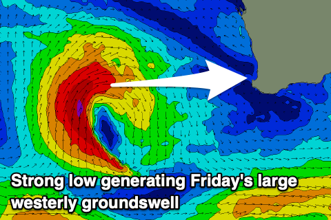
The low responsible for the onshore winds will generate a large W'ly groundswell for Friday morning though, mixed in with some mid-period energy as it aims a fetch of gale-force W/SW winds towards us.
The South West should see surf in the 10ft range, 4ft+ in Mandurah and 3-4ft across Perth.
Saturday still looks the day as the low clears to the east, allowing winds to swing back offshore from the E/NE across all locations and light N/NE into the afternoon.
Friday's swell will ease steadily, dropping back from the 6ft range in Margs, 2-3ft across Perth and Mandurah.
Sunday will become smaller again and winds will have a touch more north to them, E/NE-NE in the morning and NE into the afternoon.
Moving into next week and the swell is due to reach a low point on Monday, with a distant, long-period SW groundswell due to move in on Tuesday as winds deteriorate ahead of an approaching mid-latitude low. The groundswell is the same one thats due to fill in across J-Bay tomorrow, generated by a distant storm south-west of South Africa. As a result it'll offer no real major size as winds deteriorate.
Another large, onshore swell is due from the strong mid-latitude low mid-late next week but we'll have a closer look at this on Friday.

