Easing surf as the heat builds and wind strengthen
Western Australia Surf Forecast by Craig Brokensha (issued Wednesday December 22nd)
Best Days: Today, tomorrow selected spots in the South West, Sunday from mid-late morning ahead of sea breezes in the South West, similar Monday
Features of the Forecast (tl;dr)
- Easing mid-period SW swell tomorrow with fresh S/SE-SE winds ahead of sea breezes
- Smaller Fri with gusty SE winds ahead of sea breezes
- Low point in swell Sat with strong E/SE-E winds and sea breezes
- Building mid-period SW swell Sun with strong E/NE winds and afternoon sea breezes
- Easing swell Mon with strong E/NE tending lighter NE winds and afternoon sea breezes
Recap
Decent waves across the South West yesterday morning with a lift in swell from Monday. Conditions deteriorated through the day with strong onshore winds kicking in as the swell became larger into the afternoon. Mandurah was peaky and OK early yo 1-2ft with Perth seeing similar 1-2ft sets with weaker onshore winds.
Today the swell is on the ease and a bit smaller than expected, dropping from 6ft+ in the South West, 2ft in Mandurah and 2ft across Perth. Semi-protected spots are best with a cross-offshore wind.

Bumpy swell with a bit of south in it
This week and weekend (Dec 23 - 26)
With the peak in swell energy seen later yesterday we'll see the size continuing to ease into the end of the week as winds slowly improve and the heat builds across the state.
We'll see moderate SE-S/SE winds tomorrow morning with S/SE winds further north with easing sets from the 4ft range in the South West, 1-1.5ft in Perth and Mandurah.
Friday will see gusty SE winds but the swell will become even smaller, with limited options across the South West.
As touched on in the national Christmas Forecast we'll see stronger E/SE-E offshore winds on Christmas morning along with a low point in swell. It'll be hot but the South West magnets will be lucky to be 2ft, flat in Perth and Mandurah.
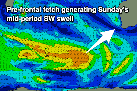
Looking at our small, mid-period SW swell for Sunday and this will be generated by a pre-frontal fetch of strong to gale-force W/NW winds firing up east of Heard Island this evening and tomorrow.
 The swell should build through Sunday and reach a fun 3-5ft across the South West into the afternoon, tiny in Mandurah to 1-1.5ft and 1ft in Perth.
Winds will be stronger out of the E/NE on Sunday morning, easing late morning and tending NE ahead of afternoon sea breezes.
Strong, hot, offshore winds are due to persist into Monday as the mid-period swell eases, with them out of the E/NE, easing and tending NE through the day ahead of late sea breezes.
Longer term we're still looking at a quieter period across the state heading into the end of next week and the start of the New Year, so make the most of the current swell and check back Friday for the latest update.

