Average weekend for most, with an improvement early next week
Western Australia Surf Forecast by Craig Brokensha (issued Friday June 4th)
Best Days: Perth and Mandurah Sunday morning, Margs for the keen Monday morning, Tuesday, early Wednesday in the South West for the desperate
Features of the Forecast (tl;dr)
- Mid-period SW swell for tomorrow with freshening W/NW winds (NE tending N/NW Perth and Mandurah)
- Better mid-period W/SW swell for Sun with light E/NE-NE tending W/SW winds in Perth and Mandurah, fresh W/SW tending SW in the South West, easing Mon with strong S/SE winds (SE Perth and Mandurah)
- Good mid-period SW swell building Mon PM, peaking Tue AM with strong E/NE winds, easing Wed with strong to near gale-force NE tending N winds
Recap
Good surf across all locations yesterday morning with a new pulse of mid-period swell to 4-6ft in the South West, 1-2ft across Mandurah and 2ft in Perth under light winds.
The swell has eased this morning and freshening N tending N/NW winds are creating deteriorating conditions around Margs, tiny and cleaner to the north.
This weekend and next week (Jun 5 - 11)
Moving into the weekend we'll see a cold front clipping the state, bringing moderate W/NW winds to the South West tomorrow morning, N/NE-NE further north, increasing in strength through the day and tending N/NW in Perth and Mandurah.
This will be with a new, mid-period SW swell from the pre-frontal part of the front, though size wise don't expect anything over 3-5ft in the South West, 1-1.5ft to the north.
 A better mid-period W/SW swell should fill in Sunday, produced by the earlier stages of the front moving in from the west through the southern Indian Ocean this week with sets to 4-6ft across the South West, 2ft in Perth and Mandurah.
Conditions will be best around Perth and Mandurah with light, morning E/NE-NE winds, shifting W/SW into the afternoon with poor, fresh W/SW tending SW winds in the South West, easing through the day.
We should see winds swing back to the S/SE across the South West on Monday morning, SE further north but the swell will be easing from a smaller 3-5ft, 1-1.5ft further north.
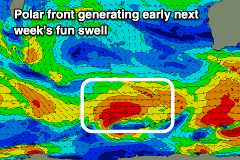
Tuesday is now looking much better for a surf with a new mid-period SW swell due to build later Monday and peak through the next morning.
The source of this swell will be a relatively weak but favourably tracking polar front, projecting from under Heard Island, up towards us through the weekend while generating strong to gale-force winds.
There should be some fun size attached to this swell, with it kicking Monday afternoon but peaking Tuesday morning to 6ft+ across the South West, 2ft+ in Mandurah and 2ft in Perth.
A deepening low west of us will bring strong E/NE winds, persisting all day as the swell eases into the afternoon. Wednesday will become poor as the swell fades under stronger NE tending N winds as the low drifts slowly south-east.
On the backside of the low, strong W/NW tending W/SW breezes are due with no significant new swell to end off the week or for next weekend.
The outlook then remains slow ahead of a possible increase in storm activity the following week, but we'll have a closer look at this Monday. Have a great weekend!

