Windy with swell
Western Australia Surf Forecast by Craig Brokensha (issued Monday February 1st)
Best Days: Tomorrow morning in the South West and Mandurah, Thursday, Friday morning in the South West, Saturday, Sunday
Features of the Forecast (tl;dr)
- Easing SW groundswell with fresh E/NE winds ahead of a S/SW-SW change tomorrow, smaller Wed with strengthening S/SE winds
- Mix of new S/SW swells Thu with strong SE-E/SE winds, easing Fri with gusty E/SE winds
- New SW groundswell building Sat with strong E/SE winds, easing Sun as winds persist
- Tropical Cyclone swell potential limited at this stage
Recap
Friday's large, powerful SW groundswell eased into Saturday but there was still some good size about and conditions were great. The South West was the pick, smaller to the north.
Yesterday was clean again with less size, best across the South West magnets, tiny to the north. Today, our reinforcing SW groundswell has filled in with a kick in size back to a great 6ft+ in the South West, 2ft+ in Mandurah through the day while Perth has unfortunately remained tiny.
This week and weekend (Feb 2 - 7)
We'll see today's swell easing back in size over the coming days, with great conditions tomorrow morning under a fresh E/NE offshore, tending variable ahead of a trough and S/SW-SW change into the afternoon. Margs should still be a good 5-6ft tomorrow morning, 2ft across Mandurah and 1-1.5ft in Perth, smaller Wednesday and less favourable with a strengthening S/SE breeze in the wake of the trough.
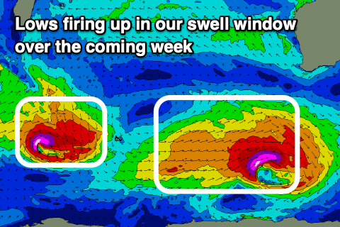
 Moving into the end of the week and we've got an upgrade in a S/SW groundswell due Thursday, with a strong polar low currently forecast to deepen significantly south-west of us this afternoon and evening.
A fetch of severe-gale to storm-force W/SW winds will be generated late in our swell window, while a trailing front will project weaker SW winds up towards us and into the Bight tomorrow evening and early Wednesday.
A mix of S/SW groundswell and mid-period S/SW swell are due Thursday, coming in around 6ft+ across the South West, 2ft in Mandurah, while Perth looks to remain tiny and to 1-1.5ft.
A high moving in under us Thursday will swing winds around to the SE (E/SE at times) across all locations, though gusty, holding all day in Perth and Mandurah but strengthening from the S/SE in the South West.
Friday looks great as winds ease a touch and swing more E/SE as the mix of swells ease back from 4-5ft+ in the South West, small to tiny to the north.
Into the weekend, another long-period SW groundswell is due, from a secondary strong polar low firing up in our swell window, though from a position slightly more west. It isn't as well aimed but we're still looking at surf to 5-6ft across the South West into Saturday afternoon/evening, 2ft in Mandurah with tiny waves to the north, easing Sunday.
Winds revolve around a tropical cyclone drifting down from the north (discussed further below) but we're looking at strong E/SE winds Saturday morning, tending variable and then stronger E/SE tending SE winds Sunday. We'll review this on Wednesday and Friday though.
 Now, looking to our north and a tropical low that's formed over the weekend is due to turn into a Tropical Cyclone over the coming 24 hours, tracking west-southwest while slowly deepening.
At this stage the swell prospects are minimal, even if it does track south adjacent our coasts, with the supporting high pressure ridge to our south-west generating strong E/SE-SE winds aimed towards the Indian Ocean. On the north-eastern and eastern flanks of the cyclone winds are much weaker and only over a small stretch of ocean. Still we'll keep an eye on this cyclone, with any swell from it likely early next week.

