Improving surf as the week develops
Western Australia Surf Forecast by Craig Brokensha (issued Monday January 25th)
Best Days: Thursday morning in the South West, Friday, Saturday morning, Monday morning
Features of the Forecast (tl;dr)
- New, mid-period SW swell for Thu with a moderate to fresh morning SE breeze
- Large SW groundswell for Fri with moderate to fresh SE winds, easing Sat with fresh morning E/SE winds
- New SW groundswell for later Sun but more so Mon AM with strong morning SE winds
Recap
Small, bumpy surf on Saturday while Sunday provided more size though with bumpy conditions continuing across the South West. Mandurah was cleaner and to 2ft, lumpy and 2ft across Perth.
This morning conditions were favourable though a bit lumpy across the coast with fun amounts of W/SW swell to 2-3ft in Perth and Mandurah, 3-5ft in the South West and best in semi-protected breaks.
This week and weekend (Jan 26 - 31)
We've got cleaner conditions expected across the state tomorrow but the swell will bottom out and reach a low point, tiny in Perth and Mandurah, with 2ft to possibly 3ft sets due across the South West. A light E/SE-SE breeze is expected ahead of strong SW sea breezes.
Wednesday will remain small with no new swell due until the afternoon and more so Thursday, this being a moderate sized mid-period swell. This swell, discussed last week, should provide inconsistent though good 4-5ft sets across the South West, 1ft to possibly 2ft in Mandurah and tiny waves in Perth.
Winds are looking a bit better for Thursday now with a moderate to fresh morning SE breeze, ahead of strong S-S/SW sea breezes.
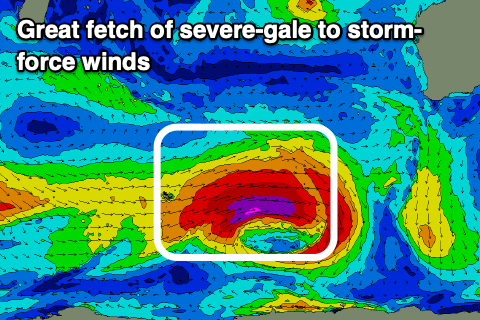
We then look at the large, long-period SW groundswell due into the end of the week, and the polar low linked to it is currently forming north-east of the Heard Island region.
A fetch of pre-frontal NW gales will give way to a much more significant fetch of severe-gale to storm-force W/SW winds, with the low weakening south-west of us on Wednesday afternoon/evening.
 This will generate a large, powerful, consistent long-period SW groundswell, arriving overnight Thursday and peaking Friday with 8-10ft+ sets in the South West, 3ft in Mandurah and 2-3ft across Perth.
Conditions look good with moderate to fresh SE winds, ahead of strong sea breezes, excellent Saturday morning as the swell eases with fresh E/SE offshore winds.
Into Sunday afternoon and more so Monday morning, a new inconsistent and smaller SW groundswell is due across the state, produced by a smaller, shorter-lived polar low firing up around the Heard Island region Wednesday/Thursday. Core wind speeds should still reach severe-gale to storm-force but the smaller scope will see the swell peak Monday morning to a smaller, less consistent 5-6ft+ in the South West, 2ft+ in Mandurah and 2ft across Perth. Conditions look to remain OK with fresh to strong morning SE winds, but we'll confirm this Friday.

