A couple of small windows for the keen
Western Australia Surf Forecast by Craig Brokensha (issued Monday January 18th)
Best Days: Early tomorrow in the South West, Friday morning in the South West, possibly Perth and Mandurah early Sunday, Monday morning in the South West
Features of the Forecast (tl;dr)
- Inconsistent SW swell building later today, easing tomorrow with early E/NE winds
- Building SW swell later Thu, easing Fri with early fresh S/SE winds
- Building W/SW groundswell late Sat, peaking Sun but with S/SW winds, cleaner and easing Mon AM
Recap
The swell bottomed out across the state on the weekend leaving no real options for a surf besides the odd small one on the small wave breaks in the South West. Similar surf is being seen today, though we should see some new, mid-period SW swell building through the afternoon. Size wise we should see 4ft sets across the South West magnets later (tiny to the north) as winds shift N/NW-N.
This week and weekend (Jan 19 - 24)
This afternoon/evening's pulse of swell is due to ease back from a similar range tomorrow, that being 4ft across the South West swell magnets (inconsistent), tiny to the north. Get in early though as a dawn E/NE offshore will shift NE mid-morning, then fresher N late morning and NW into the afternoon, back to the SW late.
Wednesday looks average as the swell bottoms out and with less favourable S/SE winds, strengthening through the day.
 Similar winds are due Thursday, fresh S/SE through the morning, stronger S/SE into the afternoon and while starting tiny, we should see some new SW swell building into the afternoon.
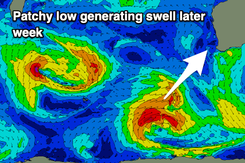
The source of the swell will be a small, tight and not overly well structured low that's currently just east of the Heard Island region. A slim fetch of W/NW gales are being generated, with a slightly better fetch of strong to sub-galeforce W/SW winds due to be generated today and tomorrow.
The swell looks a touch south of south-west in direction, building Thursday afternoon and reaching 4-5ft across the South West magnets, tiny to the north, easing from 3-5ft Friday morning. Winds look OK and moderate to fresh from the SE-S/SE Friday morning, giving into strong S/SW sea breezes.
 A new W/SW swell will take the place of the energy later week on the weekend with a mid-latitude low firing up north of the Heard Island region tomorrow. The fetch wrapping around the low isn't overly favourable (again), though we'll see still see a slither of gales projected through our swell window, producing a moderate sized W/SW swell for later Saturday but more so Sunday.
With the direction, Perth and Mandurah should offer a bit more size, coming in at 2ft+ Sunday, with 6ft waves in the South West. Unfortunately the remnants of the low will move in, bringing S/SW breezes Sunday, possibly S'ly around Perth and Mandurah early. We'll review this Wednesday.
Monday looks a bit cleaner but the swell will be on the way out.
Longer term more mid-period swell energy is on the cards for next week with average winds, but we'll have a closer look at this Wednesday.

