Winds increase but there are windows
Western Australia Surf Forecast by Craig Brokensha (issued Friday 3rd July)
Best Days: Selected spots tomorrow, Wednesday morning, Thursday protected spots, Friday
Recap
Great surf across Perth and Mandurah yesterday with clean conditions all day and easing surf from 3ft and 3-4ft respectively. Margs was still solid and around 8ft on the sets with lumpy and improving conditions as the swell eased into the afternoon.
Today the South West is perfectly clean but back to 4-5ft, clean and fun to 2ft in Mandurah and 1-2ft across Perth.

Solid yesterday morning
This weekend and next week (Jul 4 - 10)
Make the most of today as we'll see winds shift more N/NE and strengthen tomorrow ahead of an approaching trough.
At dawn we'll likely see fresh NE winds but these will quickly swing N/NE, likely backing off across all locations late in the day. Our new SW groundswell is on track, with small-ish waves to kick off the day but building to 5-6ft across the South West into the afternoon, 2ft+ in Mandurah and 1-2ft in Perth.
This swell should hold Sunday, mixed in with a less consistent W/SW groundswell but a dawn N/NE breeze will quickly shift N/NW creating deteriorating conditions. Perth and Mandurah should remain cleaner for longer though.
Monday will be a write-off with onshore W'ly winds in the wake of a change overnight Sunday, while a small low forming off our South West will generate some small localised W/SW windswell later in the day and Tuesday. As a result of the low, onshore winds will persist Tuesday, strong out of the W/SW, with better conditions on Wednesday as a high moves in.
We'll be in between swells on Wednesday though with variable winds across the South West and surf to 3-5ft or so, small and 1-2ft across Mandurah, tiny in Perth.
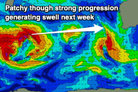
 Our new W/SW groundswell for Thursday is on track, though the strong mid-latitude frontal progression linked to it will be a little patchy in nature. The progression is currently south of South Africa and we'll see mixed fetches of severe-gale W/SW winds moving east today and through the weekend, weakening north-east of the Heard Island region Monday morning.
While not ideally structured the slow moving nature and strength of the progression should generate a large, long-period W/SW groundswell that's due to build Thursday and peak later in the day to an inconsistent 6-8ft+ across the South West, 2-3ft in Mandurah and 2ft+ in Perth.
 Winds are a little up in the air at the moment as the models diverge regarding how quickly the high will move in Thursday but we should see SE-S/SE winds across Perth and Mandurah, possibly less favourable and out of the S/SE in Margs. Friday will be great with persistent offshore winds as the swell eases.
Longer term, a very long-period but inconsistent W/SW groundswell is due to build later Friday and peak Saturday, produced by a significant storm south-west of South Africa, but by the time it reaches us it will lose most of its size. We'll still see waves to 6-8ft+ or so but with deteriorating conditions as a mid-latitude frontal progression pushes closer. This looks to also bring some new large, onshore swell, but more on this Monday. Have a great weekend!

