Large, onshore surf here all week
Western Australia Surf Forecast by Craig Brokensha (issued Monday 25th May)
Best Days: Perth and Mandurah tomorrow, Perth early Wednesday morning, Perth and Mandurah Saturday morning and Sunday
Recap
A slow start to the weekend with a new swell kicking later Saturday across the South West offering some waves for the keen (though inconsistent), slow into Sunday and only 4ft+ or so with strong offshore winds.
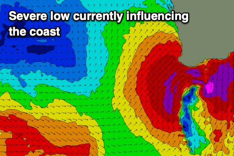
Winds deteriorated further through the day as the remnants of Tropical Cyclone Mangga drifted down through the Indian Ocean and interacted with a cold front.
The models strengthened these developments over the weekend and today we've got much stronger and stormy surf than anticipated, with the South West maxing along with the metro coastline with gale-force onshore winds. This is causing widespread erosion to the coast as well.
This week and weekend (May 26 - 31)
Buckle up, we've got more of this onshore and large messy surf on the way for the coming period as a strong and slow moving node of the Long Wave Trough that's developed over us pushes slowly east.
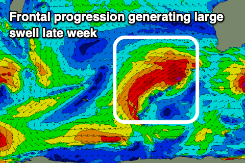
This will project and steer mid-latitude fronts up and into us over the coming week, and while late last week they were looking a little so-so, we've got a bit more intensity over the coming period.
 The downside of this is that local winds look to be stronger onshore and reaching up and into the Perth region with no let up from mid-late week.
Looking at tomorrow and we'll see the XXL stormy swell generated by the remnants of TC Mangga and the new low its formed slowly easing, but there'll still be XL waves on offer in the morning.
This is due to a fetch of severe-gale to storm-force S/SW winds being aimed towards us today, with easing surf from 12ft+ due tomorrow across the South West, 4-5ft in Mandurah 3-5ft across Perth.
Strong S/SW-SW winds will persist across the South West, improving in Perth and Mandurah from a dawn S'ly, tending more variable E-NE as the morning progresses and remaining so into the afternoon.
Wednesday will see strengthening W/NW winds across the South West and also further north (possibly N/NE at dawn in Perth) along with a new large long-period SW groundswell.
The source of this was a couple of strong polar lows around the Heard Island region and we should see Mandurah remain around 3ft, 2-3ft in Perth, while the front linked to the strengthening onshore winds will bring swell into the afternoon that's due to peak Thursday.
Margs looks to be in the 10ft range, 3ft+ across Mandurah and 3ft in Perth but with gusty W/NW-NW winds, strengthening through the day as the strongest of the frontal systems pushes up and into us.
 An elongated fetch of severe-gale W/SW winds will be projected up through our western swell window from the Heard Island region, on top an active sea state, breaking down as it moves in and across us, bringing an XL W/SW groundswell for Friday. Size wise it looks like we'll see 10-12ft surf across the South West, 3-4ft in Mandurah and 3ft across Perth but with strong W/NW-NW tending W/SW winds as the frontal passage moves across us.
The swell will ease slowly through the weekend though with onshore SW tending W winds across the South West, better and offshore in Perth and Mandurah through the morning.
The models diverge on whether we'll see another front pushing up and into us on the weekend or a clearing high bringing better winds Monday. We'll have a closer look at this in the coming updates though.

